array:2 [
"RF Query: /Property?$select=ALL&$top=20&$filter=(StandardStatus eq 'Active') and ListingKey eq 20250607212935534215000000/Property?$select=ALL&$top=20&$filter=(StandardStatus eq 'Active') and ListingKey eq 20250607212935534215000000&$expand=Media/Property?$select=ALL&$top=20&$filter=(StandardStatus eq 'Active') and ListingKey eq 20250607212935534215000000/Property?$select=ALL&$top=20&$filter=(StandardStatus eq 'Active') and ListingKey eq 20250607212935534215000000&$expand=Media&$count=true" => array:2 [
"RF Response" => Realtyna\MlsOnTheFly\Components\CloudPost\SubComponents\RFClient\SDK\RF\RFResponse {#4801
+items: array:1 [
0 => Realtyna\MlsOnTheFly\Components\CloudPost\SubComponents\RFClient\SDK\RF\Entities\RFProperty {#4799
+post_id: "63237"
+post_author: 1
+"ListingKey": "20250607212935534215000000"
+"ListingId": "6877324"
+"PropertyType": "Land"
+"StandardStatus": "Active"
+"ModificationTimestamp": "2025-06-08T02:03:31Z"
+"RFModificationTimestamp": "2025-06-08T02:07:36.553711+00:00"
+"ListPrice": 74900.0
+"BathroomsTotalInteger": 0
+"BathroomsHalf": 0
+"BedroomsTotal": 0
+"LotSizeArea": 2.0
+"LivingArea": 0
+"BuildingAreaTotal": 0
+"City": "Tonopah"
+"PostalCode": "85354"
+"UnparsedAddress": "38xxx W Willetta Streets, Tonopah, Arizona 85354"
+"Coordinates": array:2 [
0 => -112.885069
1 => 33.462721
]
+"Latitude": 33.462721
+"Longitude": -112.885069
+"YearBuilt": 0
+"InternetAddressDisplayYN": true
+"FeedTypes": "IDX"
+"ListAgentFullName": "Rommel J Cantu Cuadras"
+"ListOfficeName": "DeLex Realty"
+"ListAgentMlsId": "rc624"
+"ListOfficeMlsId": "dele001"
+"OriginatingSystemName": "ARMLS"
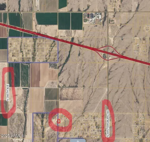
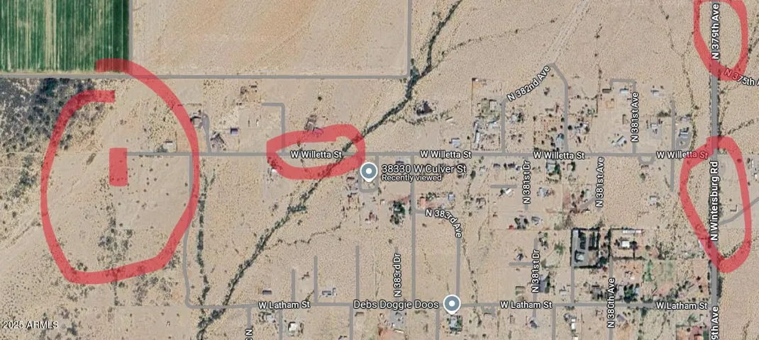
+"PublicRemarks": """
Great location of this 2 acres Parcel Lot in Tonopah, AZ. Excellent Investment, close to the Freeway I-10 & Wintersburg Ave, short distance to Elementary and High School, as well as gas stations, restaurants, etc. with access to both Electricity and Water, power close and shared well. Financing Through Hard Money Lenders Available!\r\n
Buyer to verify all facts.
"""
+"ApprovalStatus": true
+"ContractStatusChangeDate": "2025-06-07"
+"Country": "US"
+"CountyOrParish": "Maricopa"
+"CreationDate": "2025-06-07T23:59:08.407291+00:00"
+"CrossStreet": "Willetta St and 386th Ave"
+"DevelopmentStatus": array:1 [
0 => "Raw Land"
]
+"Directions": "From I-10 exit Wintersburg, go South to Willetta St, go right at the end of the street, property is on left side of road."
+"Disclosures": array:1 [
0 => "Other (See Rmks)"
]
+"DistanceToElectricComments": "Within 1/2 Mile"
+"DistanceToGasComments": "None"
+"DistanceToPhoneServiceComments": "None"
+"DistanceToSewerComments": "None"
+"DistanceToWaterComments": "Under 350 Feet"
+"DocumentsChangeTimestamp": "2025-06-07T23:54:48Z"
+"Electric": array:1 [
0 => "APS"
]
+"ElementarySchoolDistrict": "Saddle Mountain Unified School District"
+"Fencing": array:1 [
0 => "None"
]
+"HighSchool": "Tonopah Valley High School"
+"HighSchoolDistrict": "Saddle Mountain Unified School District"
+"HorseAmenities": array:1 [
0 => "Other"
]
+"HorseYN": true
+"RFTransactionType": "For Sale"
+"InternetEntireListingDisplayYN": true
+"ListAgentAOR": "Phoenix REALTORS"
+"ListAgentFirstName": "Rommel"
+"ListAgentKey": "20180621181544086958000000"
+"ListAgentLastName": "Cantu Cuadras"
+"ListAgentPreferredPhone": "602-574-4054"
+"ListOfficeEmail": "[email protected]"
+"ListOfficeKey": "20130906155159427027000000"
+"ListOfficePhone": "602-910-3002"
+"ListingContractDate": "2025-06-07"
+"ListingTerms": "Cash,Conventional"
+"LotFeatures": array:1 [
0 => "Other"
]
+"LotSizeAcres": 2.0
+"LotSizeDimensions": "220X395"
+"LotSizeSquareFeet": 87122.0
+"MlsStatus": "Active"
+"OnMarketDate": "2025-06-07"
+"OriginalEntryTimestamp": "2025-06-08T01:54:48Z"
+"OriginatingSystemID": "M00000048"
+"OriginatingSystemKey": "20250607212935534215000000"
+"OtherStructures": array:1 [
0 => "None"
]
+"ParcelNumber": "506-45-337-A"
+"PhotosChangeTimestamp": "2025-06-08T00:17:34Z"
+"PhotosCount": 4
+"PossibleUse": array:3 [
0 => "Single Family"
1 => "Mobile/Mgf Hme/RV's"
2 => "Recreational"
]
+"PostalCity": "Tonopah"
+"RoadSurfaceType": array:1 [
0 => "Dirt"
]
+"Sewer": "None"
+"SourceSystemID": "M00000048"
+"SourceSystemKey": "20250607212935534215000000"
+"SourceSystemName": "Arizona Regional Multiple Listing Service (ARMLS)"
+"SpecialListingConditions": array:1 [
0 => "N/A"
]
+"StateOrProvince": "AZ"
+"StatusChangeTimestamp": "2025-06-07T23:54:48Z"
+"StreetDirPrefix": "W"
+"StreetName": "Willetta"
+"StreetNumber": "38XXX"
+"StreetNumberNumeric": "38"
+"StreetSuffix": "Streets"
+"TaxAnnualAmount": "196.0"
+"TaxBookNumber": "506.00"
+"TaxLot": "-"
+"TaxMapNumber": "45.00"
+"TaxParcelLetter": "A"
+"TaxYear": "2024"
+"Topography": "Level"
+"UnitNumber": "-"
+"Vegetation": array:1 [
0 => "Low Desert"
]
+"View": array:2 [
0 => "Mountain(s)"
1 => "Desert"
]
+"WaterSource": array:1 [
0 => "Shared Well"
]
+"Zoning": "RU-43"
+"Gas_co_None28": true
+"View_co_Desert": true
+"Electric_co_APS2": true
+"Fencing_co_None11": true
+"RoadsStreets_co_Dirt": true
+"Topography_co_Level2": true
+"[email protected]": "None"
+"[email protected]": "None"
+"[email protected]": "None"
+"[email protected]": "None"
+"[email protected]": "None"
+"[email protected]": "None"
+"[email protected]": "None"
+"[email protected]": "None"
+"[email protected]": "None"
+"[email protected]": "None"
+"[email protected]": "None"
+"[email protected]": "None"
+"Lockbox_sp_Type_co_None43": true
+"New_sp_Financing_co_Cash3": true
+"[email protected]": "None"
+"[email protected]": "None"
+"[email protected]": "None"
+"[email protected]": "None"
+"[email protected]": "None"
+"[email protected]": "None"
+"[email protected]": "None"
+"[email protected]": "None"
+"Sewer_co_No_sp_SewerSeptic": true
+"[email protected]": "None"
+"[email protected]": "None"
+"[email protected]": "None"
+"[email protected]": "None"
+"[email protected]": "None"
+"[email protected]": "None"
+"[email protected]": "None"
+"Horse_sp_Features_co_Other3": true
+"Land_sp_Features_co_Other14": true
+"[email protected]": "None"
+"[email protected]": "None"
+"[email protected]": "None"
+"[email protected]": "None"
+"Vegetation_co_Low_sp_Desert": true
+"[email protected]": "None"
+"[email protected]": "None"
+"[email protected]": "None"
+"[email protected]": "None"
+"[email protected]": "None"
+"[email protected]": "None"
+"[email protected]": "None"
+"[email protected]": "None"
+"[email protected]": "None"
+"[email protected]": "None"
+"[email protected]": "None"
+"[email protected]": "None"
+"[email protected]": "None"
+"[email protected]": "None"
+"[email protected]": "None"
+"[email protected]": "None"
+"[email protected]": "None"
+"[email protected]": "None"
+"[email protected]": "None"
+"[email protected]": "None"
+"[email protected]": "None"
+"[email protected]": "None"
+"[email protected]": "None"
+"[email protected]": "None"
+"[email protected]": "None"
+"Pmt_sp_Rate_sp_Info_co_Equity": 74900.0
+"[email protected]": "None"
+"[email protected]": "None"
+"[email protected]": "None"
+"[email protected]": "None"
+"[email protected]": "None"
+"[email protected]": "None"
+"AssocProp_sp_Info_co_HOA_sp_YN": "N"
+"[email protected]": "None"
+"[email protected]": "None"
+"[email protected]": "None"
+"[email protected]": "None"
+"[email protected]": "None"
+"[email protected]": "None"
+"[email protected]": "None"
+"[email protected]": "None"
+"[email protected]": "None"
+"Distance_sp_to_sp_Gas_co_None8": true
+"[email protected]": "None"
+"[email protected]": "None"
+"[email protected]": "None"
+"[email protected]": "None"
+"[email protected]": "None"
+"[email protected]": "None"
+"[email protected]": "None"
+"[email protected]": "None"
+"[email protected]": "None"
+"[email protected]": "None"
+"[email protected]": "None"
+"[email protected]": "None"
+"[email protected]": "None"
+"Existing_sp_Structures_co_None4": true
+"[email protected]": "None"
+"[email protected]": "None"
+"[email protected]": "None"
+"[email protected]": "None"
+"[email protected]": "None"
+"[email protected]": "None"
+"[email protected]": "None"
+"[email protected]": "None"
+"[email protected]": "None"
+"[email protected]": "None"
+"[email protected]": "None"
+"[email protected]": "None"
+"Contract_sp_Information_co_Type3": "Exclusive Right To Sell"
+"[email protected]": "None"
+"Distance_sp_to_sp_Cable_co_None2": true
+"Distance_sp_to_sp_Phone_co_None3": true
+"Distance_sp_to_sp_Sewer_co_None7": true
+"[email protected]": "None"
+"[email protected]": "None"
+"[email protected]": "None"
+"[email protected]": "None"
+"[email protected]": "None"
+"[email protected]": "None"
+"[email protected]": "None"
+"[email protected]": "None"
+"[email protected]": "None"
+"[email protected]": "None"
+"[email protected]": "None"
+"Special_sp_Listing_sp_Cond_co_NA": true
+"[email protected]": "None"
+"[email protected]": "None"
+"[email protected]": "None"
+"[email protected]": "None"
+"[email protected]": "None"
+"[email protected]": "None"
+"[email protected]": "None"
+"[email protected]": "None"
+"[email protected]": "None"
+"[email protected]": "None"
+"[email protected]": "None"
+"[email protected]": "None"
+"[email protected]": "None"
+"[email protected]": "None"
+"[email protected]": "None"
+"[email protected]": "None"
+"New_sp_Financing_co_Conventional5": true
+"[email protected]": "None"
+"[email protected]": "None"
+"Potential_sp_Use_co_Recreational2": true
+"[email protected]": "None"
+"[email protected]": "None"
+"[email protected]": "None"
+"[email protected]": "None"
+"[email protected]": "None"
+"[email protected]": "None"
+"[email protected]": "None"
+"[email protected]": "None"
+"[email protected]": "None"
+"Location_sp_Tax_sp_Legal_co_Taxes2": 196.0
+"[email protected]": "None"
+"[email protected]": "None"
+"[email protected]": "None"
+"[email protected]": "None"
+"[email protected]": "None"
+"[email protected]": "None"
+"[email protected]": "None"
+"[email protected]": "None"
+"[email protected]": "None"
+"Water_sp_Source_co_Shared_sp_Well2": true
+"[email protected]": "None"
+"[email protected]": "None"
+"[email protected]": "None"
+"[email protected]": "None"
+"[email protected]": "None"
+"[email protected]": "None"
+"[email protected]": "None"
+"[email protected]": "None"
+"[email protected]": "None"
+"[email protected]": "None"
+"[email protected]": "None"
+"[email protected]": "None"
+"[email protected]": "None"
+"[email protected]": "None"
+"Zoned_sp_Presently_co_Recreational3": true
+"AssocProp_sp_Info_co_HOA_sp_2_sp_YN2": "N"
+"[email protected]": "None"
+"[email protected]": "None"
+"[email protected]": "None"
+"[email protected]": "None"
+"Development_sp_Status_co_Raw_sp_Land": true
+"[email protected]": "None"
+"[email protected]": "None"
+"Pmt_sp_Rate_sp_Info_co_Total_sp_Owed": 0.0
+"[email protected]": "None"
+"AssocProp_sp_Info_co_PAD_sp_Fee_sp_YN": "N"
+"[email protected]": "None"
+"[email protected]": "None"
+"[email protected]": "None"
+"[email protected]": "None"
+"[email protected]": "None"
+"[email protected]": "None"
+"[email protected]": "None"
+"[email protected]": "None"
+"[email protected]": "None"
+"[email protected]": "None"
+"[email protected]": "None"
+"Potential_sp_Use_co_Single_sp_Family2": true
+"[email protected]": "None"
+"[email protected]": "None"
+"[email protected]": "None"
+"[email protected]": "None"
+"[email protected]": "None"
+"[email protected]": "None"
+"[email protected]": "None"
+"[email protected]": "None"
+"[email protected]": "None"
+"[email protected]": "None"
+"[email protected]": "None"
+"[email protected]": "None"
+"[email protected]": "None"
+"[email protected]": "None"
+"[email protected]": "None"
+"[email protected]": "None"
+"Zoned_sp_Presently_co_Single_sp_Family": true
+"[email protected]": "None"
+"[email protected]": "None"
+"[email protected]": "None"
+"[email protected]": "None"
+"[email protected]": "None"
+"[email protected]": "None"
+"[email protected]": "None"
+"[email protected]": "None"
+"AssocProp_sp_Info_co_Assessed_sp_Balance": 0.0
+"[email protected]": "None"
+"[email protected]": "None"
+"[email protected]": "None"
+"[email protected]": "None"
+"[email protected]": "None"
+"[email protected]": "None"
+"[email protected]": "None"
+"[email protected]": "None"
+"[email protected]": "None"
+"View_co_Mountain_sp_View_lparen_s_rparen_": true
+"[email protected]": "None"
+"Location_sp_Tax_sp_Legal_co_Lot_sp__pound_": "-"
+"[email protected]": "None"
+"[email protected]": "None"
+"Showing_sp_Notification_sp_Methods_co_Text": true
+"[email protected]": "None"
+"Showing_sp_Notification_sp_Methods_co_Email": true
+"AssocProp_sp_Info_co_Assessed_sp_Yrs_sp_Left": 0
+"[email protected]": "None"
+"General_sp_Property_sp_Description_co_Horses": "Y"
+"[email protected]": "None"
+"[email protected]": "None"
+"FreewayHighway_co_21_sp__hyphen__sp_5_sp_Miles": true
+"Land_sp_Configuration_co_Square_sp_Rectangular": true
+"[email protected]": "None"
+"Potential_sp_Use_co_MobileMgf_sp_HmeRV_squote_s": true
+"Distance_sp_to_sp_Water_co_Under_sp_350_sp_Feet2": true
+"Location_sp_Tax_sp_Legal_co_Tax_sp_Municipality3": "Maricopa - COUNTY"
+"General_sp_Property_sp_Description_co_Apx_sp_SqFt": 87122.0
+"Parcel_sp_Size_co_100_sp__hyphen__sp_249_sp_Acres": true
+"Railroad_co_Other_sp__lparen_See_sp_Rmks_rparen_16": true
+"Distance_sp_to_sp_Electric_co_Within_sp_12_sp_Mile4": true
+"Location_sp_Tax_sp_Legal_co_Add_squote_l_sp_Parcels": "No"
+"Showing_sp_Notification_sp_Methods_co_Phone_sp_Call": true
+"General_sp_Property_sp_Description_co_High_sp_School": "Tonopah Valley High School"
+"Contract_sp_Information_co_For_sp_Sale_sp_or_sp_Lease": "Sale"
+"Location_sp_Tax_sp_Legal_co_Assessor_sp_Parcel_sp_Ltr3": "A"
+"Road_sp_Responsibility_co_County_sp_Maintained_sp_Road": true
+"Environmental_co_Other_sp__lparen_See_sp_Rmks_rparen_10": true
+"General_sp_Property_sp_Description_co_Apx_sp_SqFt_sp_GN": "N"
+"Showing_sp_Notification_sp_Methods_co_Showing_sp_Service": "Aligned Showings"
+"General_sp_Property_sp_Description_co_Price_sp_Per_sp_Acre": 37450.0
+"General_sp_Property_sp_Description_co_Apx_sp_Total_sp_Acres": 2.0
+"General_sp_Property_sp_Description_co_Price_sp_Per_sp_SqFt2": 0.86
+"ReportsDisclosures_co_Other_sp__lparen_See_sp_Rmks_rparen_9": true
+"Use_sp_Restrictions_co_Other_sp__lparen_See_sp_Rmks_rparen_8": true
+"General_sp_Property_sp_Description_co_Lot_sp_Size_sp_Dimensions": "220X395"
+"Existing_sp_1st_sp_Loan_co_Other_sp__lparen_See_sp_Rmks_rparen_2": true
+"Location_sp_Tax_sp_Legal_co_Assessor_squote_s_sp_Map_sp__pound_3": 45.0
+"Existing_sp_Land_sp_Use_co_Other_sp__lparen_See_sp_Rmks_rparen_11": true
+"General_sp_Property_sp_Description_co_Apx_sp_Total_sp_Acres_sp_GN": "N"
+"General_sp_Property_sp_Description_co_High_sp_School_sp_District2": "Saddle Mountain Unified School District"
+"Location_sp_Tax_sp_Legal_co_Assessor_squote_s_sp_Parcel_sp__pound_3": 337.0
+"General_sp_Property_sp_Description_co_Elementary_sp_School_sp_District2": "Saddle Mountain Unified School District"
+"Showing_sp_Notification_sp_Methods_co_No_sp_Notification_sp_Required_sp_to_sp_Show": true
+"@odata.id": "https://api.realtyfeed.com/reso/odata/Property('20250607212935534215000000')"
+"provider_name": "ARMLS"
+"Media": array:4 [
0 => array:16 [
"Order" => 1
"MediaKey" => "20250608001720419239000000"
"MediaURL" => "https://cdn.realtyfeed.com/cdn/54/20250607212935534215000000/d720649593c84209b8de44f01800a157.webp"
"@odata.id" => "https://replication.sparkapi.com/Version/2/Reso/OData/Property('20250607212935534215000000')/Media('20250608001720419239000000')"
"MediaHTML" => null
"MediaSize" => 208429
"MediaType" => "webp"
"Thumbnail" => "https://cdn.realtyfeed.com/cdn/54/20250607212935534215000000/thumbnail-d720649593c84209b8de44f01800a157.webp"
"Permission" => array:1 [ …1]
"MediaCategory" => "Photo"
"LongDescription" => ""
"PreferredPhotoYN" => true
"ResourceRecordID" => "20250607212935534215000000"
"ShortDescription" => "Screenshot 2025-06-07 143702"
"ResourceRecordKey" => "20250607212935534215000000"
"OriginatingSystemMediaKey" => "20250608001720419239000000"
]
1 => array:16 [
"Order" => 2
"MediaKey" => "20250608001723301015000000"
"MediaURL" => "https://cdn.realtyfeed.com/cdn/54/20250607212935534215000000/a9cadb535167f218e576d49f78895e60.webp"
"@odata.id" => "https://replication.sparkapi.com/Version/2/Reso/OData/Property('20250607212935534215000000')/Media('20250608001723301015000000')"
"MediaHTML" => null
"MediaSize" => 157641
"MediaType" => "webp"
"Thumbnail" => "https://cdn.realtyfeed.com/cdn/54/20250607212935534215000000/thumbnail-a9cadb535167f218e576d49f78895e60.webp"
"Permission" => array:1 [ …1]
"MediaCategory" => "Photo"
"LongDescription" => ""
"PreferredPhotoYN" => false
"ResourceRecordID" => "20250607212935534215000000"
"ShortDescription" => "Screenshot 2025-06-07 143811"
"ResourceRecordKey" => "20250607212935534215000000"
"OriginatingSystemMediaKey" => "20250608001723301015000000"
]
2 => array:16 [
"Order" => 3
"MediaKey" => "20250608001729481969000000"
"MediaURL" => "https://cdn.realtyfeed.com/cdn/54/20250607212935534215000000/2ba12bbd25d7c55357109a5cecbcac24.webp"
"@odata.id" => "https://replication.sparkapi.com/Version/2/Reso/OData/Property('20250607212935534215000000')/Media('20250608001729481969000000')"
"MediaHTML" => null
"MediaSize" => 113659
"MediaType" => "webp"
"Thumbnail" => "https://cdn.realtyfeed.com/cdn/54/20250607212935534215000000/thumbnail-2ba12bbd25d7c55357109a5cecbcac24.webp"
"Permission" => array:1 [ …1]
"MediaCategory" => "Photo"
"LongDescription" => ""
"PreferredPhotoYN" => false
"ResourceRecordID" => "20250607212935534215000000"
"ShortDescription" => "Screenshot 2025-06-07 144009"
"ResourceRecordKey" => "20250607212935534215000000"
"OriginatingSystemMediaKey" => "20250608001729481969000000"
]
3 => array:16 [
"Order" => 4
"MediaKey" => "20250608001732636276000000"
"MediaURL" => "https://cdn.realtyfeed.com/cdn/54/20250607212935534215000000/eac0ded2a851914b394364f9e0147ff2.webp"
"@odata.id" => "https://replication.sparkapi.com/Version/2/Reso/OData/Property('20250607212935534215000000')/Media('20250608001732636276000000')"
"MediaHTML" => null
"MediaSize" => 218154
"MediaType" => "webp"
"Thumbnail" => "https://cdn.realtyfeed.com/cdn/54/20250607212935534215000000/thumbnail-eac0ded2a851914b394364f9e0147ff2.webp"
"Permission" => array:1 [ …1]
"MediaCategory" => "Photo"
"LongDescription" => ""
"PreferredPhotoYN" => false
"ResourceRecordID" => "20250607212935534215000000"
"ShortDescription" => "Screenshot 2025-06-07 171512"
"ResourceRecordKey" => "20250607212935534215000000"
"OriginatingSystemMediaKey" => "20250608001732636276000000"
]
]
+"ID": "63237"
}
]
+success: true
+page_size: 1
+page_count: 1
+count: 1
+after_key: ""
}
"RF Response Time" => "0.11 seconds"
]
"RF Query: /Property?$select=ALL&$orderby=ModificationTimestamp DESC&$top=4&$filter=(StandardStatus eq 'Active') and PropertyType eq 'Land' AND City eq 'Tonopah'/Property?$select=ALL&$orderby=ModificationTimestamp DESC&$top=4&$filter=(StandardStatus eq 'Active') and PropertyType eq 'Land' AND City eq 'Tonopah'&$expand=Media/Property?$select=ALL&$orderby=ModificationTimestamp DESC&$top=4&$filter=(StandardStatus eq 'Active') and PropertyType eq 'Land' AND City eq 'Tonopah'/Property?$select=ALL&$orderby=ModificationTimestamp DESC&$top=4&$filter=(StandardStatus eq 'Active') and PropertyType eq 'Land' AND City eq 'Tonopah'&$expand=Media&$count=true" => array:2 [
"RF Response" => Realtyna\MlsOnTheFly\Components\CloudPost\SubComponents\RFClient\SDK\RF\RFResponse {#5775
+items: array:4 [
0 => Realtyna\MlsOnTheFly\Components\CloudPost\SubComponents\RFClient\SDK\RF\Entities\RFProperty {#5776
+post_id: "63237"
+post_author: 1
+"ListingKey": "20250607212935534215000000"
+"ListingId": "6877324"
+"PropertyType": "Land"
+"StandardStatus": "Active"
+"ModificationTimestamp": "2025-06-08T02:03:31Z"
+"RFModificationTimestamp": "2025-06-08T02:07:36.553711+00:00"
+"ListPrice": 74900.0
+"BathroomsTotalInteger": 0
+"BathroomsHalf": 0
+"BedroomsTotal": 0
+"LotSizeArea": 2.0
+"LivingArea": 0
+"BuildingAreaTotal": 0
+"City": "Tonopah"
+"PostalCode": "85354"
+"UnparsedAddress": "38xxx W Willetta Streets, Tonopah, Arizona 85354"
+"Coordinates": array:2 [
0 => -112.885069
1 => 33.462721
]
+"Latitude": 33.462721
+"Longitude": -112.885069
+"YearBuilt": 0
+"InternetAddressDisplayYN": true
+"FeedTypes": "IDX"
+"ListAgentFullName": "Rommel J Cantu Cuadras"
+"ListOfficeName": "DeLex Realty"
+"ListAgentMlsId": "rc624"
+"ListOfficeMlsId": "dele001"
+"OriginatingSystemName": "ARMLS"
+"PublicRemarks": """
Great location of this 2 acres Parcel Lot in Tonopah, AZ. Excellent Investment, close to the Freeway I-10 & Wintersburg Ave, short distance to Elementary and High School, as well as gas stations, restaurants, etc. with access to both Electricity and Water, power close and shared well. Financing Through Hard Money Lenders Available!\r\n
Buyer to verify all facts.
"""
+"ApprovalStatus": true
+"ContractStatusChangeDate": "2025-06-07"
+"Country": "US"
+"CountyOrParish": "Maricopa"
+"CreationDate": "2025-06-07T23:59:08.407291+00:00"
+"CrossStreet": "Willetta St and 386th Ave"
+"DevelopmentStatus": array:1 [
0 => "Raw Land"
]
+"Directions": "From I-10 exit Wintersburg, go South to Willetta St, go right at the end of the street, property is on left side of road."
+"Disclosures": array:1 [
0 => "Other (See Rmks)"
]
+"DistanceToElectricComments": "Within 1/2 Mile"
+"DistanceToGasComments": "None"
+"DistanceToPhoneServiceComments": "None"
+"DistanceToSewerComments": "None"
+"DistanceToWaterComments": "Under 350 Feet"
+"DocumentsChangeTimestamp": "2025-06-07T23:54:48Z"
+"Electric": array:1 [
0 => "APS"
]
+"ElementarySchoolDistrict": "Saddle Mountain Unified School District"
+"Fencing": array:1 [
0 => "None"
]
+"HighSchool": "Tonopah Valley High School"
+"HighSchoolDistrict": "Saddle Mountain Unified School District"
+"HorseAmenities": array:1 [
0 => "Other"
]
+"HorseYN": true
+"RFTransactionType": "For Sale"
+"InternetEntireListingDisplayYN": true
+"ListAgentAOR": "Phoenix REALTORS"
+"ListAgentFirstName": "Rommel"
+"ListAgentKey": "20180621181544086958000000"
+"ListAgentLastName": "Cantu Cuadras"
+"ListAgentPreferredPhone": "602-574-4054"
+"ListOfficeEmail": "[email protected]"
+"ListOfficeKey": "20130906155159427027000000"
+"ListOfficePhone": "602-910-3002"
+"ListingContractDate": "2025-06-07"
+"ListingTerms": "Cash,Conventional"
+"LotFeatures": array:1 [
0 => "Other"
]
+"LotSizeAcres": 2.0
+"LotSizeDimensions": "220X395"
+"LotSizeSquareFeet": 87122.0
+"MlsStatus": "Active"
+"OnMarketDate": "2025-06-07"
+"OriginalEntryTimestamp": "2025-06-08T01:54:48Z"
+"OriginatingSystemID": "M00000048"
+"OriginatingSystemKey": "20250607212935534215000000"
+"OtherStructures": array:1 [
0 => "None"
]
+"ParcelNumber": "506-45-337-A"
+"PhotosChangeTimestamp": "2025-06-08T00:17:34Z"
+"PhotosCount": 4
+"PossibleUse": array:3 [
0 => "Single Family"
1 => "Mobile/Mgf Hme/RV's"
2 => "Recreational"
]
+"PostalCity": "Tonopah"
+"RoadSurfaceType": array:1 [
0 => "Dirt"
]
+"Sewer": "None"
+"SourceSystemID": "M00000048"
+"SourceSystemKey": "20250607212935534215000000"
+"SourceSystemName": "Arizona Regional Multiple Listing Service (ARMLS)"
+"SpecialListingConditions": array:1 [
0 => "N/A"
]
+"StateOrProvince": "AZ"
+"StatusChangeTimestamp": "2025-06-07T23:54:48Z"
+"StreetDirPrefix": "W"
+"StreetName": "Willetta"
+"StreetNumber": "38XXX"
+"StreetNumberNumeric": "38"
+"StreetSuffix": "Streets"
+"TaxAnnualAmount": "196.0"
+"TaxBookNumber": "506.00"
+"TaxLot": "-"
+"TaxMapNumber": "45.00"
+"TaxParcelLetter": "A"
+"TaxYear": "2024"
+"Topography": "Level"
+"UnitNumber": "-"
+"Vegetation": array:1 [
0 => "Low Desert"
]
+"View": array:2 [
0 => "Mountain(s)"
1 => "Desert"
]
+"WaterSource": array:1 [
0 => "Shared Well"
]
+"Zoning": "RU-43"
+"Gas_co_None28": true
+"View_co_Desert": true
+"Electric_co_APS2": true
+"Fencing_co_None11": true
+"RoadsStreets_co_Dirt": true
+"Topography_co_Level2": true
+"[email protected]": "None"
+"[email protected]": "None"
+"[email protected]": "None"
+"[email protected]": "None"
+"[email protected]": "None"
+"[email protected]": "None"
+"[email protected]": "None"
+"[email protected]": "None"
+"[email protected]": "None"
+"[email protected]": "None"
+"[email protected]": "None"
+"[email protected]": "None"
+"Lockbox_sp_Type_co_None43": true
+"New_sp_Financing_co_Cash3": true
+"[email protected]": "None"
+"[email protected]": "None"
+"[email protected]": "None"
+"[email protected]": "None"
+"[email protected]": "None"
+"[email protected]": "None"
+"[email protected]": "None"
+"[email protected]": "None"
+"Sewer_co_No_sp_SewerSeptic": true
+"[email protected]": "None"
+"[email protected]": "None"
+"[email protected]": "None"
+"[email protected]": "None"
+"[email protected]": "None"
+"[email protected]": "None"
+"[email protected]": "None"
+"Horse_sp_Features_co_Other3": true
+"Land_sp_Features_co_Other14": true
+"[email protected]": "None"
+"[email protected]": "None"
+"[email protected]": "None"
+"[email protected]": "None"
+"Vegetation_co_Low_sp_Desert": true
+"[email protected]": "None"
+"[email protected]": "None"
+"[email protected]": "None"
+"[email protected]": "None"
+"[email protected]": "None"
+"[email protected]": "None"
+"[email protected]": "None"
+"[email protected]": "None"
+"[email protected]": "None"
+"[email protected]": "None"
+"[email protected]": "None"
+"[email protected]": "None"
+"[email protected]": "None"
+"[email protected]": "None"
+"[email protected]": "None"
+"[email protected]": "None"
+"[email protected]": "None"
+"[email protected]": "None"
+"[email protected]": "None"
+"[email protected]": "None"
+"[email protected]": "None"
+"[email protected]": "None"
+"[email protected]": "None"
+"[email protected]": "None"
+"[email protected]": "None"
+"Pmt_sp_Rate_sp_Info_co_Equity": 74900.0
+"[email protected]": "None"
+"[email protected]": "None"
+"[email protected]": "None"
+"[email protected]": "None"
+"[email protected]": "None"
+"[email protected]": "None"
+"AssocProp_sp_Info_co_HOA_sp_YN": "N"
+"[email protected]": "None"
+"[email protected]": "None"
+"[email protected]": "None"
+"[email protected]": "None"
+"[email protected]": "None"
+"[email protected]": "None"
+"[email protected]": "None"
+"[email protected]": "None"
+"[email protected]": "None"
+"Distance_sp_to_sp_Gas_co_None8": true
+"[email protected]": "None"
+"[email protected]": "None"
+"[email protected]": "None"
+"[email protected]": "None"
+"[email protected]": "None"
+"[email protected]": "None"
+"[email protected]": "None"
+"[email protected]": "None"
+"[email protected]": "None"
+"[email protected]": "None"
+"[email protected]": "None"
+"[email protected]": "None"
+"[email protected]": "None"
+"Existing_sp_Structures_co_None4": true
+"[email protected]": "None"
+"[email protected]": "None"
+"[email protected]": "None"
+"[email protected]": "None"
+"[email protected]": "None"
+"[email protected]": "None"
+"[email protected]": "None"
+"[email protected]": "None"
+"[email protected]": "None"
+"[email protected]": "None"
+"[email protected]": "None"
+"[email protected]": "None"
+"Contract_sp_Information_co_Type3": "Exclusive Right To Sell"
+"[email protected]": "None"
+"Distance_sp_to_sp_Cable_co_None2": true
+"Distance_sp_to_sp_Phone_co_None3": true
+"Distance_sp_to_sp_Sewer_co_None7": true
+"[email protected]": "None"
+"[email protected]": "None"
+"[email protected]": "None"
+"[email protected]": "None"
+"[email protected]": "None"
+"[email protected]": "None"
+"[email protected]": "None"
+"[email protected]": "None"
+"[email protected]": "None"
+"[email protected]": "None"
+"[email protected]": "None"
+"Special_sp_Listing_sp_Cond_co_NA": true
+"[email protected]": "None"
+"[email protected]": "None"
+"[email protected]": "None"
+"[email protected]": "None"
+"[email protected]": "None"
+"[email protected]": "None"
+"[email protected]": "None"
+"[email protected]": "None"
+"[email protected]": "None"
+"[email protected]": "None"
+"[email protected]": "None"
+"[email protected]": "None"
+"[email protected]": "None"
+"[email protected]": "None"
+"[email protected]": "None"
+"[email protected]": "None"
+"New_sp_Financing_co_Conventional5": true
+"[email protected]": "None"
+"[email protected]": "None"
+"Potential_sp_Use_co_Recreational2": true
+"[email protected]": "None"
+"[email protected]": "None"
+"[email protected]": "None"
+"[email protected]": "None"
+"[email protected]": "None"
+"[email protected]": "None"
+"[email protected]": "None"
+"[email protected]": "None"
+"[email protected]": "None"
+"Location_sp_Tax_sp_Legal_co_Taxes2": 196.0
+"[email protected]": "None"
+"[email protected]": "None"
+"[email protected]": "None"
+"[email protected]": "None"
+"[email protected]": "None"
+"[email protected]": "None"
+"[email protected]": "None"
+"[email protected]": "None"
+"[email protected]": "None"
+"Water_sp_Source_co_Shared_sp_Well2": true
+"[email protected]": "None"
+"[email protected]": "None"
+"[email protected]": "None"
+"[email protected]": "None"
+"[email protected]": "None"
+"[email protected]": "None"
+"[email protected]": "None"
+"[email protected]": "None"
+"[email protected]": "None"
+"[email protected]": "None"
+"[email protected]": "None"
+"[email protected]": "None"
+"[email protected]": "None"
+"[email protected]": "None"
+"Zoned_sp_Presently_co_Recreational3": true
+"AssocProp_sp_Info_co_HOA_sp_2_sp_YN2": "N"
+"[email protected]": "None"
+"[email protected]": "None"
+"[email protected]": "None"
+"[email protected]": "None"
+"Development_sp_Status_co_Raw_sp_Land": true
+"[email protected]": "None"
+"[email protected]": "None"
+"Pmt_sp_Rate_sp_Info_co_Total_sp_Owed": 0.0
+"[email protected]": "None"
+"AssocProp_sp_Info_co_PAD_sp_Fee_sp_YN": "N"
+"[email protected]": "None"
+"[email protected]": "None"
+"[email protected]": "None"
+"[email protected]": "None"
+"[email protected]": "None"
+"[email protected]": "None"
+"[email protected]": "None"
+"[email protected]": "None"
+"[email protected]": "None"
+"[email protected]": "None"
+"[email protected]": "None"
+"Potential_sp_Use_co_Single_sp_Family2": true
+"[email protected]": "None"
+"[email protected]": "None"
+"[email protected]": "None"
+"[email protected]": "None"
+"[email protected]": "None"
+"[email protected]": "None"
+"[email protected]": "None"
+"[email protected]": "None"
+"[email protected]": "None"
+"[email protected]": "None"
+"[email protected]": "None"
+"[email protected]": "None"
+"[email protected]": "None"
+"[email protected]": "None"
+"[email protected]": "None"
+"[email protected]": "None"
+"Zoned_sp_Presently_co_Single_sp_Family": true
+"[email protected]": "None"
+"[email protected]": "None"
+"[email protected]": "None"
+"[email protected]": "None"
+"[email protected]": "None"
+"[email protected]": "None"
+"[email protected]": "None"
+"[email protected]": "None"
+"AssocProp_sp_Info_co_Assessed_sp_Balance": 0.0
+"[email protected]": "None"
+"[email protected]": "None"
+"[email protected]": "None"
+"[email protected]": "None"
+"[email protected]": "None"
+"[email protected]": "None"
+"[email protected]": "None"
+"[email protected]": "None"
+"[email protected]": "None"
+"View_co_Mountain_sp_View_lparen_s_rparen_": true
+"[email protected]": "None"
+"Location_sp_Tax_sp_Legal_co_Lot_sp__pound_": "-"
+"[email protected]": "None"
+"[email protected]": "None"
+"Showing_sp_Notification_sp_Methods_co_Text": true
+"[email protected]": "None"
+"Showing_sp_Notification_sp_Methods_co_Email": true
+"AssocProp_sp_Info_co_Assessed_sp_Yrs_sp_Left": 0
+"[email protected]": "None"
+"General_sp_Property_sp_Description_co_Horses": "Y"
+"[email protected]": "None"
+"[email protected]": "None"
+"FreewayHighway_co_21_sp__hyphen__sp_5_sp_Miles": true
+"Land_sp_Configuration_co_Square_sp_Rectangular": true
+"[email protected]": "None"
+"Potential_sp_Use_co_MobileMgf_sp_HmeRV_squote_s": true
+"Distance_sp_to_sp_Water_co_Under_sp_350_sp_Feet2": true
+"Location_sp_Tax_sp_Legal_co_Tax_sp_Municipality3": "Maricopa - COUNTY"
+"General_sp_Property_sp_Description_co_Apx_sp_SqFt": 87122.0
+"Parcel_sp_Size_co_100_sp__hyphen__sp_249_sp_Acres": true
+"Railroad_co_Other_sp__lparen_See_sp_Rmks_rparen_16": true
+"Distance_sp_to_sp_Electric_co_Within_sp_12_sp_Mile4": true
+"Location_sp_Tax_sp_Legal_co_Add_squote_l_sp_Parcels": "No"
+"Showing_sp_Notification_sp_Methods_co_Phone_sp_Call": true
+"General_sp_Property_sp_Description_co_High_sp_School": "Tonopah Valley High School"
+"Contract_sp_Information_co_For_sp_Sale_sp_or_sp_Lease": "Sale"
+"Location_sp_Tax_sp_Legal_co_Assessor_sp_Parcel_sp_Ltr3": "A"
+"Road_sp_Responsibility_co_County_sp_Maintained_sp_Road": true
+"Environmental_co_Other_sp__lparen_See_sp_Rmks_rparen_10": true
+"General_sp_Property_sp_Description_co_Apx_sp_SqFt_sp_GN": "N"
+"Showing_sp_Notification_sp_Methods_co_Showing_sp_Service": "Aligned Showings"
+"General_sp_Property_sp_Description_co_Price_sp_Per_sp_Acre": 37450.0
+"General_sp_Property_sp_Description_co_Apx_sp_Total_sp_Acres": 2.0
+"General_sp_Property_sp_Description_co_Price_sp_Per_sp_SqFt2": 0.86
+"ReportsDisclosures_co_Other_sp__lparen_See_sp_Rmks_rparen_9": true
+"Use_sp_Restrictions_co_Other_sp__lparen_See_sp_Rmks_rparen_8": true
+"General_sp_Property_sp_Description_co_Lot_sp_Size_sp_Dimensions": "220X395"
+"Existing_sp_1st_sp_Loan_co_Other_sp__lparen_See_sp_Rmks_rparen_2": true
+"Location_sp_Tax_sp_Legal_co_Assessor_squote_s_sp_Map_sp__pound_3": 45.0
+"Existing_sp_Land_sp_Use_co_Other_sp__lparen_See_sp_Rmks_rparen_11": true
+"General_sp_Property_sp_Description_co_Apx_sp_Total_sp_Acres_sp_GN": "N"
+"General_sp_Property_sp_Description_co_High_sp_School_sp_District2": "Saddle Mountain Unified School District"
+"Location_sp_Tax_sp_Legal_co_Assessor_squote_s_sp_Parcel_sp__pound_3": 337.0
+"General_sp_Property_sp_Description_co_Elementary_sp_School_sp_District2": "Saddle Mountain Unified School District"
+"Showing_sp_Notification_sp_Methods_co_No_sp_Notification_sp_Required_sp_to_sp_Show": true
+"@odata.id": "https://api.realtyfeed.com/reso/odata/Property('20250607212935534215000000')"
+"provider_name": "ARMLS"
+"Media": array:4 [
0 => array:16 [
"Order" => 1
"MediaKey" => "20250608001720419239000000"
"MediaURL" => "https://cdn.realtyfeed.com/cdn/54/20250607212935534215000000/d720649593c84209b8de44f01800a157.webp"
"@odata.id" => "https://replication.sparkapi.com/Version/2/Reso/OData/Property('20250607212935534215000000')/Media('20250608001720419239000000')"
"MediaHTML" => null
"MediaSize" => 208429
"MediaType" => "webp"
"Thumbnail" => "https://cdn.realtyfeed.com/cdn/54/20250607212935534215000000/thumbnail-d720649593c84209b8de44f01800a157.webp"
"Permission" => array:1 [ …1]
"MediaCategory" => "Photo"
"LongDescription" => ""
"PreferredPhotoYN" => true
"ResourceRecordID" => "20250607212935534215000000"
"ShortDescription" => "Screenshot 2025-06-07 143702"
"ResourceRecordKey" => "20250607212935534215000000"
"OriginatingSystemMediaKey" => "20250608001720419239000000"
]
1 => array:16 [
"Order" => 2
"MediaKey" => "20250608001723301015000000"
"MediaURL" => "https://cdn.realtyfeed.com/cdn/54/20250607212935534215000000/a9cadb535167f218e576d49f78895e60.webp"
"@odata.id" => "https://replication.sparkapi.com/Version/2/Reso/OData/Property('20250607212935534215000000')/Media('20250608001723301015000000')"
"MediaHTML" => null
"MediaSize" => 157641
"MediaType" => "webp"
"Thumbnail" => "https://cdn.realtyfeed.com/cdn/54/20250607212935534215000000/thumbnail-a9cadb535167f218e576d49f78895e60.webp"
"Permission" => array:1 [ …1]
"MediaCategory" => "Photo"
"LongDescription" => ""
"PreferredPhotoYN" => false
"ResourceRecordID" => "20250607212935534215000000"
"ShortDescription" => "Screenshot 2025-06-07 143811"
"ResourceRecordKey" => "20250607212935534215000000"
"OriginatingSystemMediaKey" => "20250608001723301015000000"
]
2 => array:16 [
"Order" => 3
"MediaKey" => "20250608001729481969000000"
"MediaURL" => "https://cdn.realtyfeed.com/cdn/54/20250607212935534215000000/2ba12bbd25d7c55357109a5cecbcac24.webp"
"@odata.id" => "https://replication.sparkapi.com/Version/2/Reso/OData/Property('20250607212935534215000000')/Media('20250608001729481969000000')"
"MediaHTML" => null
"MediaSize" => 113659
"MediaType" => "webp"
"Thumbnail" => "https://cdn.realtyfeed.com/cdn/54/20250607212935534215000000/thumbnail-2ba12bbd25d7c55357109a5cecbcac24.webp"
"Permission" => array:1 [ …1]
"MediaCategory" => "Photo"
"LongDescription" => ""
"PreferredPhotoYN" => false
"ResourceRecordID" => "20250607212935534215000000"
"ShortDescription" => "Screenshot 2025-06-07 144009"
"ResourceRecordKey" => "20250607212935534215000000"
"OriginatingSystemMediaKey" => "20250608001729481969000000"
]
3 => array:16 [
"Order" => 4
"MediaKey" => "20250608001732636276000000"
"MediaURL" => "https://cdn.realtyfeed.com/cdn/54/20250607212935534215000000/eac0ded2a851914b394364f9e0147ff2.webp"
"@odata.id" => "https://replication.sparkapi.com/Version/2/Reso/OData/Property('20250607212935534215000000')/Media('20250608001732636276000000')"
"MediaHTML" => null
"MediaSize" => 218154
"MediaType" => "webp"
"Thumbnail" => "https://cdn.realtyfeed.com/cdn/54/20250607212935534215000000/thumbnail-eac0ded2a851914b394364f9e0147ff2.webp"
"Permission" => array:1 [ …1]
"MediaCategory" => "Photo"
"LongDescription" => ""
"PreferredPhotoYN" => false
"ResourceRecordID" => "20250607212935534215000000"
"ShortDescription" => "Screenshot 2025-06-07 171512"
"ResourceRecordKey" => "20250607212935534215000000"
"OriginatingSystemMediaKey" => "20250608001732636276000000"
]
]
+"ID": "63237"
}
1 => Realtyna\MlsOnTheFly\Components\CloudPost\SubComponents\RFClient\SDK\RF\Entities\RFProperty {#5771
+post_id: "39433"
+post_author: 1
+"ListingKey": "20250313001027637879000000"
+"ListingId": "6842232"
+"PropertyType": "Land"
+"StandardStatus": "Active"
+"ModificationTimestamp": "2025-06-07T19:46:10Z"
+"RFModificationTimestamp": "2025-06-07T19:48:23.267716+00:00"
+"ListPrice": 105000.0
+"BathroomsTotalInteger": 0
+"BathroomsHalf": 0
+"BedroomsTotal": 0
+"LotSizeArea": 2.54
+"LivingArea": 0
+"BuildingAreaTotal": 0
+"City": "Tonopah"
+"PostalCode": "85354"
+"UnparsedAddress": "38200 W Latham Street, 2, Tonopah, Az 85354"
+"Coordinates": array:2 [
0 => -112.875774
1 => 33.460611
]
+"Latitude": 33.460611
+"Longitude": -112.875774
+"YearBuilt": 0
+"InternetAddressDisplayYN": true
+"FeedTypes": "IDX"
+"ListAgentFullName": "Robert Thunhorst"
+"ListOfficeName": "Superstars Realty"
+"ListAgentMlsId": "rt145"
+"ListOfficeMlsId": "rwss01"
+"OriginatingSystemName": "ARMLS"
+"PublicRemarks": "The prime location is close to 379th, and this flat, 2.54-acre lot is ready to build with power close and shared well."
+"ApprovalStatus": true
+"CoListAgentEmail": "info@Art Welch.com"
+"CoListAgentFax": "623-298-5660"
+"CoListAgentFirstName": "Arthur"
+"CoListAgentFullName": "Arthur Welch"
+"CoListAgentKey": "20071208001429559093000000"
+"CoListAgentLastName": "Welch"
+"CoListAgentMlsId": "aw191"
+"CoListAgentMobilePhone": "623-687-7852"
+"CoListAgentPreferredPhone": "623-687-7852"
+"CoListAgentURL": "https://www.artwelch.com"
+"CoListOfficeKey": "20080322084248407808000000"
+"CoListOfficeMlsId": "rwss01"
+"CoListOfficeName": "Superstars Realty"
+"ContractStatusChangeDate": "2025-03-27"
+"Country": "US"
+"CountyOrParish": "Maricopa"
+"CreationDate": "2025-03-29T06:55:03.689296+00:00"
+"CrossStreet": "Latham & 383rd Ave"
+"DevelopmentStatus": array:1 [
0 => "Raw Land"
]
+"Directions": "From 379th and Latham head west to 383rd Ave then north 360 feet"
+"Disclosures": array:1 [
0 => "None"
]
+"DistanceToElectricComments": "Within 1/2 Mile"
+"DistanceToGasComments": "None"
+"DistanceToPhoneServiceComments": "None"
+"DistanceToSewerComments": "None"
+"DistanceToWaterComments": "Under 350 Feet"
+"DocumentsChangeTimestamp": "2025-03-28T02:23:44Z"
+"Electric": array:1 [
0 => "APS"
]
+"ElementarySchool": "Ruth Fisher Middle School"
+"ElementarySchoolDistrict": "Saddle Mountain Unified School District"
+"HighSchool": "Tonopah Valley High School"
+"HighSchoolDistrict": "Saddle Mountain Unified School District"
+"HorseYN": true
+"RFTransactionType": "For Sale"
+"InternetEntireListingDisplayYN": true
+"ListAgentAOR": "We SERV"
+"ListAgentFax": "623-298-5690"
+"ListAgentFirstName": "Robert"
+"ListAgentHomePhone": "623-398-6534"
+"ListAgentKey": "20071208002621770232000000"
+"ListAgentLastName": "Thunhorst"
+"ListAgentPreferredPhone": "623-687-6065"
+"ListOfficeEmail": "[email protected]"
+"ListOfficeFax": "623-298-5660"
+"ListOfficeKey": "20080322084248407808000000"
+"ListOfficePhone": "623-239-0926"
+"ListOfficeURL": "http://www.superstarsrealtygroup.com"
+"ListingContractDate": "2025-03-12"
+"ListingTerms": "Cash,No Carry"
+"LotSizeAcres": 2.54
+"LotSizeDimensions": "SQ"
+"LotSizeSquareFeet": 110564.0
+"MiddleOrJuniorSchool": "Ruth Fisher Middle School"
+"MlsStatus": "Active"
+"OnMarketDate": "2025-03-28"
+"OriginalEntryTimestamp": "2025-03-28T04:23:44Z"
+"OriginatingSystemID": "M00000048"
+"OriginatingSystemKey": "20250313001027637879000000"
+"OtherStructures": array:1 [
0 => "None"
]
+"ParcelNumber": "506-45-296-K"
+"PhotosChangeTimestamp": "2025-03-28T22:27:53Z"
+"PhotosCount": 3
+"PossibleUse": array:3 [
0 => "Single Family"
1 => "Mobile/Mgf Hme/RV's"
2 => "Rural"
]
+"PostalCity": "Tonopah"
+"PriceChangeTimestamp": "2025-06-07T19:45:48Z"
+"RoadResponsibility": array:1 [
0 => "Private Maintained Road"
]
+"RoadSurfaceType": array:1 [
0 => "Gravel"
]
+"Sewer": "None"
+"SourceSystemID": "M00000048"
+"SourceSystemKey": "20250313001027637879000000"
+"SourceSystemName": "Arizona Regional Multiple Listing Service (ARMLS)"
+"SpecialListingConditions": array:1 [
0 => "Owner/Agent"
]
+"StateOrProvince": "AZ"
+"StatusChangeTimestamp": "2025-03-28T02:23:44Z"
+"StreetDirPrefix": "W"
+"StreetName": "Latham"
+"StreetNumber": "38200"
+"StreetNumberNumeric": "38200"
+"StreetSuffix": "Street"
+"TaxAnnualAmount": "127.0"
+"TaxBookNumber": "506.00"
+"TaxLot": "2"
+"TaxMapNumber": "45.00"
+"TaxParcelLetter": "K"
+"TaxYear": "2024"
+"Topography": "Level"
+"UnitNumber": "2"
+"Vegetation": array:1 [
0 => "Natural Vegetation"
]
+"View": array:1 [
0 => "Desert"
]
+"WaterSource": array:1 [
0 => "Shared Well"
]
+"Zoning": "R - 43"
+"Gas_co_None28": true
+"View_co_Desert": true
+"Electric_co_APS2": true
+"Topography_co_Level2": true
+"[email protected]": "None"
+"[email protected]": "None"
+"RoadsStreets_co_Gravel": true
+"[email protected]": "None"
+"Environmental_co_None26": true
+"[email protected]": "None"
+"[email protected]": "None"
+"[email protected]": "None"
+"[email protected]": "None"
+"[email protected]": "None"
+"[email protected]": "None"
+"[email protected]": "None"
+"[email protected]": "None"
+"[email protected]": "None"
+"Lockbox_sp_Type_co_None43": true
+"New_sp_Financing_co_Cash3": true
+"[email protected]": "None"
+"[email protected]": "None"
+"[email protected]": "None"
+"[email protected]": "None"
+"[email protected]": "None"
+"[email protected]": "None"
+"[email protected]": "None"
+"[email protected]": "None"
+"Potential_sp_Use_co_Rural2": true
+"Sewer_co_No_sp_SewerSeptic": true
+"[email protected]": "None"
+"[email protected]": "None"
+"[email protected]": "None"
+"[email protected]": "None"
+"[email protected]": "None"
+"[email protected]": "None"
+"[email protected]": "None"
+"[email protected]": "None"
+"[email protected]": "None"
+"[email protected]": "None"
+"[email protected]": "None"
+"Traffic_sp_Count_co_Unknown": true
+"Zoned_sp_Presently_co_Rural": true
+"[email protected]": "None"
+"[email protected]": "None"
+"[email protected]": "None"
+"[email protected]": "None"
+"[email protected]": "None"
+"[email protected]": "None"
+"[email protected]": "None"
+"[email protected]": "None"
+"[email protected]": "None"
+"[email protected]": "None"
+"[email protected]": "None"
+"ReportsDisclosures_co_None25": true
+"[email protected]": "None"
+"[email protected]": "None"
+"[email protected]": "None"
+"[email protected]": "None"
+"[email protected]": "None"
+"[email protected]": "None"
+"[email protected]": "None"
+"[email protected]": "None"
+"[email protected]": "None"
+"[email protected]": "None"
+"[email protected]": "None"
+"[email protected]": "None"
+"[email protected]": "None"
+"[email protected]": "None"
+"Pmt_sp_Rate_sp_Info_co_Equity": 145000.0
+"[email protected]": "None"
+"[email protected]": "None"
+"[email protected]": "None"
+"[email protected]": "None"
+"[email protected]": "None"
+"[email protected]": "None"
+"AssocProp_sp_Info_co_HOA_sp_YN": "N"
+"[email protected]": "None"
+"[email protected]": "None"
+"[email protected]": "None"
+"[email protected]": "None"
+"[email protected]": "None"
+"[email protected]": "None"
+"[email protected]": "None"
+"[email protected]": "None"
+"[email protected]": "None"
+"Distance_sp_to_sp_Gas_co_None8": true
+"[email protected]": "None"
+"[email protected]": "None"
+"[email protected]": "None"
+"[email protected]": "None"
+"[email protected]": "None"
+"[email protected]": "None"
+"[email protected]": "None"
+"[email protected]": "None"
+"[email protected]": "None"
+"[email protected]": "None"
+"[email protected]": "None"
+"[email protected]": "None"
+"[email protected]": "None"
+"Existing_sp_Structures_co_None4": true
+"[email protected]": "None"
+"[email protected]": "None"
+"[email protected]": "None"
+"New_sp_Financing_co_No_sp_Carry": true
+"[email protected]": "None"
+"[email protected]": "None"
+"[email protected]": "None"
+"[email protected]": "None"
+"[email protected]": "None"
+"[email protected]": "None"
+"[email protected]": "None"
+"[email protected]": "None"
+"[email protected]": "None"
+"Contract_sp_Information_co_Type3": "Exclusive Agency"
+"[email protected]": "None"
+"Distance_sp_to_sp_Cable_co_None2": true
+"Distance_sp_to_sp_Phone_co_None3": true
+"Distance_sp_to_sp_Sewer_co_None7": true
+"[email protected]": "None"
+"[email protected]": "None"
+"[email protected]": "None"
+"[email protected]": "None"
+"[email protected]": "None"
+"[email protected]": "None"
+"[email protected]": "None"
+"[email protected]": "None"
+"[email protected]": "None"
+"[email protected]": "None"
+"[email protected]": "None"
+"[email protected]": "None"
+"[email protected]": "None"
+"[email protected]": "None"
+"[email protected]": "None"
+"[email protected]": "None"
+"[email protected]": "None"
+"[email protected]": "None"
+"[email protected]": "None"
+"[email protected]": "None"
+"[email protected]": "None"
+"[email protected]": "None"
+"[email protected]": "None"
+"[email protected]": "None"
+"[email protected]": "None"
+"[email protected]": "None"
+"[email protected]": "None"
+"[email protected]": "None"
+"[email protected]": "None"
+"[email protected]": "None"
+"[email protected]": "None"
+"[email protected]": "None"
+"[email protected]": "None"
+"[email protected]": "None"
+"[email protected]": "None"
+"[email protected]": "None"
+"[email protected]": "None"
+"[email protected]": "None"
+"Location_sp_Tax_sp_Legal_co_Taxes2": 127.0
+"[email protected]": "None"
+"[email protected]": "None"
+"[email protected]": "None"
+"[email protected]": "None"
+"[email protected]": "None"
+"[email protected]": "None"
+"[email protected]": "None"
+"[email protected]": "None"
+"[email protected]": "None"
+"Water_sp_Source_co_Shared_sp_Well2": true
+"[email protected]": "None"
+"[email protected]": "None"
+"[email protected]": "None"
+"[email protected]": "None"
+"[email protected]": "None"
+"[email protected]": "None"
+"[email protected]": "None"
+"[email protected]": "None"
+"[email protected]": "None"
+"[email protected]": "None"
+"[email protected]": "None"
+"[email protected]": "None"
+"[email protected]": "None"
+"[email protected]": "None"
+"Vegetation_co_Natural_sp_Vegetation": true
+"AssocProp_sp_Info_co_HOA_sp_2_sp_YN2": "N"
+"[email protected]": "None"
+"[email protected]": "None"
+"[email protected]": "None"
+"[email protected]": "None"
+"Development_sp_Status_co_Raw_sp_Land": true
+"[email protected]": "None"
+"[email protected]": "None"
+"Pmt_sp_Rate_sp_Info_co_Total_sp_Owed": 0.0
+"[email protected]": "None"
+"AssocProp_sp_Info_co_PAD_sp_Fee_sp_YN": "N"
+"[email protected]": "None"
+"[email protected]": "None"
+"[email protected]": "None"
+"[email protected]": "None"
+"[email protected]": "None"
+"[email protected]": "None"
+"[email protected]": "None"
+"[email protected]": "None"
+"[email protected]": "None"
+"[email protected]": "None"
+"[email protected]": "None"
+"Potential_sp_Use_co_Single_sp_Family2": true
+"[email protected]": "None"
+"[email protected]": "None"
+"[email protected]": "None"
+"[email protected]": "None"
+"[email protected]": "None"
+"[email protected]": "None"
+"[email protected]": "None"
+"[email protected]": "None"
+"[email protected]": "None"
+"[email protected]": "None"
+"[email protected]": "None"
+"[email protected]": "None"
+"[email protected]": "None"
+"[email protected]": "None"
+"[email protected]": "None"
+"[email protected]": "None"
+"Zoned_sp_Presently_co_Single_sp_Family": true
+"[email protected]": "None"
+"[email protected]": "None"
+"[email protected]": "None"
+"[email protected]": "None"
+"[email protected]": "None"
+"[email protected]": "None"
+"[email protected]": "None"
+"[email protected]": "None"
+"AssocProp_sp_Info_co_Assessed_sp_Balance": 0.0
+"[email protected]": "None"
+"[email protected]": "None"
+"[email protected]": "None"
+"[email protected]": "None"
+"[email protected]": "None"
+"Special_sp_Listing_sp_Cond_co_OwnerAgent": true
+"[email protected]": "None"
+"[email protected]": "None"
+"[email protected]": "None"
+"[email protected]": "None"
+"[email protected]": "None"
+"Location_sp_Tax_sp_Legal_co_Lot_sp__pound_": "2"
+"[email protected]": "None"
+"[email protected]": "None"
+"Elevation_co_1001_sp__hyphen__sp_2000_sp_Ft": true
+"[email protected]": "None"
+"AssocProp_sp_Info_co_Assessed_sp_Yrs_sp_Left": 0
+"[email protected]": "None"
+"General_sp_Property_sp_Description_co_Horses": "Y"
+"[email protected]": "None"
+"Existing_sp_Land_sp_Use_co_Residential_sp_Lot": true
+"[email protected]": "None"
+"Land_sp_Configuration_co_Square_sp_Rectangular": true
+"[email protected]": "None"
+"Contact_sp_Info_co_List_sp_Agent_sp_Home_sp_Phn": "623-398-6534"
+"Existing_sp_Other_sp_Loan_co_Not_sp_Applicable4": true
+"Potential_sp_Use_co_MobileMgf_sp_HmeRV_squote_s": true
+"Distance_sp_to_sp_Water_co_Under_sp_350_sp_Feet2": true
+"Location_sp_Tax_sp_Legal_co_Tax_sp_Municipality3": "Maricopa - COUNTY"
+"General_sp_Property_sp_Description_co_Apx_sp_SqFt": 110564.0
+"Parcel_sp_Size_co_250_sp__hyphen__sp_499_sp_Acres": true
+"Existing_sp_3rd_sp_Ln_sp_Type_co_Not_sp_Applicable": true
+"Distance_sp_to_sp_Electric_co_Within_sp_12_sp_Mile4": true
+"Existing_sp_2nd_sp_Ln_sp_Trms_co_Not_sp_Applicable7": true
+"Existing_sp_2nd_sp_Ln_sp_Type_co_Not_sp_Applicable2": true
+"Existing_sp_3rd_sp_Ln_sp_Trms_co_Not_sp_Applicable6": true
+"Existing_sp_Land_sp_Use_co_MobileMfg_sp_Home_sp_Lot": true
+"General_sp_Property_sp_Description_co_Flood_sp_Zone": "No"
+"Location_sp_Tax_sp_Legal_co_Add_squote_l_sp_Parcels": "No"
+"Existing_sp_1st_sp_Loan_co_Treat_sp_as_sp_FreeClear3": true
+"Existing_sp_2nd_sp_Loan_co_Treat_sp_as_sp_FreeClear5": true
+"Existing_sp_3rd_sp_Loan_co_Treat_sp_as_sp_FreeClear6": true
+"General_sp_Property_sp_Description_co_High_sp_School": "Tonopah Valley High School"
+"Contract_sp_Information_co_For_sp_Sale_sp_or_sp_Lease": "Sale"
+"Location_sp_Tax_sp_Legal_co_Assessor_sp_Parcel_sp_Ltr3": "K"
+"General_sp_Property_sp_Description_co_Apx_sp_SqFt_sp_GN": "N"
+"Road_sp_Responsibility_co_Private_sp_Maintained_sp_Road": true
+"Showing_sp_Notification_sp_Methods_co_Showing_sp_Service": "No Showing Service Used"
+"General_sp_Property_sp_Description_co_Elementary_sp_School": "Ruth Fisher Middle School"
+"General_sp_Property_sp_Description_co_Jr_sp_High_sp_School": "Ruth Fisher Middle School"
+"General_sp_Property_sp_Description_co_Price_sp_Per_sp_Acre": 41338.58
+"General_sp_Property_sp_Description_co_Apx_sp_Total_sp_Acres": 2.54
+"General_sp_Property_sp_Description_co_Price_sp_Per_sp_SqFt2": 0.95
+"Current_sp_Density_co_00_sp__hyphen__sp_01_sp_Units_sp_PAcre": true
+"Proposed_sp_Density_co_00_sp__hyphen__sp_01_sp_Units_sp_PAcre2": true
+"General_sp_Property_sp_Description_co_Lot_sp_Size_sp_Dimensions": "SQ"
+"Location_sp_Tax_sp_Legal_co_Assessor_squote_s_sp_Map_sp__pound_3": 45.0
+"General_sp_Property_sp_Description_co_Apx_sp_Total_sp_Acres_sp_GN": "N"
+"General_sp_Property_sp_Description_co_High_sp_School_sp_District2": "Saddle Mountain Unified School District"
+"Location_sp_Tax_sp_Legal_co_Assessor_squote_s_sp_Parcel_sp__pound_3": 296.0
+"General_sp_Property_sp_Description_co_Elementary_sp_School_sp_District2": "Saddle Mountain Unified School District"
+"Showing_sp_Notification_sp_Methods_co_No_sp_Notification_sp_Required_sp_to_sp_Show": true
+"@odata.id": "https://api.realtyfeed.com/reso/odata/Property('20250313001027637879000000')"
+"provider_name": "ARMLS"
+"Media": array:3 [
0 => array:16 [
"Order" => 1
"MediaKey" => "20250328222746404691000000"
"MediaURL" => "https://dx41nk9nsacii.cloudfront.net/cdn/54/20250313001027637879000000/aa17bda6fbab32ed0a35c363a114ae31.webp"
"@odata.id" => "https://replication.sparkapi.com/Version/2/Reso/OData/Property('20250313001027637879000000')/Media('20250328222746404691000000')"
"MediaHTML" => null
"MediaSize" => 1496645
"MediaType" => "webp"
"Thumbnail" => "https://dx41nk9nsacii.cloudfront.net/cdn/54/20250313001027637879000000/thumbnail-aa17bda6fbab32ed0a35c363a114ae31.webp"
"Permission" => array:1 [ …1]
"MediaCategory" => "Photo"
"LongDescription" => ""
"PreferredPhotoYN" => true
"ResourceRecordID" => "20250313001027637879000000"
"ShortDescription" => "20250328_141157"
"ResourceRecordKey" => "20250313001027637879000000"
"OriginatingSystemMediaKey" => "20250328222746404691000000"
]
1 => array:16 [
"Order" => 2
"MediaKey" => "20250328222749278475000000"
"MediaURL" => "https://dx41nk9nsacii.cloudfront.net/cdn/54/20250313001027637879000000/e42fc72cc6b175f337725a1a28963744.webp"
"@odata.id" => "https://replication.sparkapi.com/Version/2/Reso/OData/Property('20250313001027637879000000')/Media('20250328222749278475000000')"
"MediaHTML" => null
"MediaSize" => 1260618
"MediaType" => "webp"
"Thumbnail" => "https://dx41nk9nsacii.cloudfront.net/cdn/54/20250313001027637879000000/thumbnail-e42fc72cc6b175f337725a1a28963744.webp"
"Permission" => array:1 [ …1]
"MediaCategory" => "Photo"
"LongDescription" => ""
"PreferredPhotoYN" => false
"ResourceRecordID" => "20250313001027637879000000"
"ShortDescription" => "20250328_141204"
"ResourceRecordKey" => "20250313001027637879000000"
"OriginatingSystemMediaKey" => "20250328222749278475000000"
]
2 => array:16 [
"Order" => 3
"MediaKey" => "20250328222752189865000000"
"MediaURL" => "https://dx41nk9nsacii.cloudfront.net/cdn/54/20250313001027637879000000/de0b868ebd91e5eb8f87fff91625e573.webp"
"@odata.id" => "https://replication.sparkapi.com/Version/2/Reso/OData/Property('20250313001027637879000000')/Media('20250328222752189865000000')"
"MediaHTML" => null
"MediaSize" => 1504834
"MediaType" => "webp"
"Thumbnail" => "https://dx41nk9nsacii.cloudfront.net/cdn/54/20250313001027637879000000/thumbnail-de0b868ebd91e5eb8f87fff91625e573.webp"
"Permission" => array:1 [ …1]
"MediaCategory" => "Photo"
"LongDescription" => ""
"PreferredPhotoYN" => false
"ResourceRecordID" => "20250313001027637879000000"
"ShortDescription" => "20250328_141351"
"ResourceRecordKey" => "20250313001027637879000000"
"OriginatingSystemMediaKey" => "20250328222752189865000000"
]
]
+"ID": "39433"
}
2 => Realtyna\MlsOnTheFly\Components\CloudPost\SubComponents\RFClient\SDK\RF\Entities\RFProperty {#5777
+post_id: "56863"
+post_author: 1
+"ListingKey": "20250531155342969814000000"
+"ListingId": "6874957"
+"PropertyType": "Land"
+"StandardStatus": "Active"
+"ModificationTimestamp": "2025-06-07T18:26:26Z"
+"RFModificationTimestamp": "2025-06-07T18:31:13.765524+00:00"
+"ListPrice": 95000.0
+"BathroomsTotalInteger": 0
+"BathroomsHalf": 0
+"BedroomsTotal": 0
+"LotSizeArea": 5.0
+"LivingArea": 0
+"BuildingAreaTotal": 0
+"City": "Tonopah"
+"PostalCode": "85354"
+"UnparsedAddress": "6651 N 415th Avenue, Tonopah, Arizona 85354"
+"Coordinates": array:2 [
0 => -112.945667
1 => 33.525951
]
+"Latitude": 33.525951
+"Longitude": -112.945667
+"YearBuilt": 0
+"InternetAddressDisplayYN": true
+"FeedTypes": "IDX"
+"ListAgentFullName": "Joe Dodani"
+"ListOfficeName": "eXp Realty"
+"ListAgentMlsId": "jd346"
+"ListOfficeMlsId": "xpre07"
+"OriginatingSystemName": "ARMLS"
+"PublicRemarks": """
Great vacant lot with mountain views and custom and manufactured homes located nearby. This is a 5-acre lot. It can be divided into 5 1 Acre lot. This listing is for 5 Acre parcel. \r\n
please see attached document \r\n
Tonopah Highlights
"""
+"ApprovalStatus": true
+"CoListAgentEmail": "[email protected]"
+"CoListAgentFirstName": "Nehal"
+"CoListAgentFullName": "Nehal Shah"
+"CoListAgentKey": "20240510160846262896000000"
+"CoListAgentLastName": "Shah"
+"CoListAgentMlsId": "ns489"
+"CoListAgentMobilePhone": "602-614-9155"
+"CoListAgentPreferredPhone": "602-614-9155"
+"CoListOfficeKey": "20091109230618809261000000"
+"CoListOfficeMlsId": "xpre01"
+"CoListOfficeName": "eXp Realty"
+"ContractStatusChangeDate": "2025-06-03"
+"Country": "US"
+"CountyOrParish": "Maricopa"
+"CreationDate": "2025-06-03T19:10:32.456319+00:00"
+"CrossStreet": "I-10 & 411st Ave"
+"DevelopmentStatus": array:1 [
0 => "Raw Land"
]
+"Directions": """
N to Bethany Home Rd West to 415th Ave North to property on east side of roadway.\r\n
\r\n
Use google link for exact location.\r\n
http://maps.google.com/maps?q=33.5304525875002,-112.942352389277
"""
+"Disclosures": array:1 [
0 => "Seller Prop Disc Stm"
]
+"DistanceToElectricComments": "Within 1/2 Mile"
+"DistanceToGasComments": "None"
+"DistanceToPhoneServiceComments": "Call Listing Office"
+"DistanceToSewerComments": "None"
+"DistanceToWaterComments": "None"
+"DocumentsChangeTimestamp": "2025-06-03T19:02:29Z"
+"Electric": array:1 [
0 => "None"
]
+"ElementarySchoolDistrict": "Saddle Mountain Unified School District"
+"HighSchoolDistrict": "Saddle Mountain Unified School District"
+"HorseYN": true
+"RFTransactionType": "For Sale"
+"InternetEntireListingDisplayYN": true
+"ListAgentAOR": "Scottsdale"
+"ListAgentFax": "866-433-0577"
+"ListAgentFirstName": "Joe"
+"ListAgentHomePhone": "480-200-7127"
+"ListAgentKey": "20071208001944312101000000"
+"ListAgentLastName": "Dodani"
+"ListAgentPreferredPhone": "480-200-7127"
+"ListAgentURL": "http://justlandarizona.com/"
+"ListOfficeEmail": "[email protected]"
+"ListOfficeKey": "20171116204742912403000000"
+"ListOfficePhone": "888-897-7821"
+"ListingContractDate": "2025-06-03"
+"ListingTerms": "Cash"
+"LotSizeAcres": 5.0
+"LotSizeDimensions": "IRR"
+"LotSizeSquareFeet": 217800.0
+"MlsStatus": "Active"
+"OnMarketDate": "2025-06-03"
+"OriginalEntryTimestamp": "2025-06-03T21:02:28Z"
+"OriginatingSystemID": "M00000048"
+"OriginatingSystemKey": "20250531155342969814000000"
+"OtherStructures": array:1 [
0 => "None"
]
+"ParcelNumber": "506-35-672-W"
+"PhotosChangeTimestamp": "2025-06-07T18:25:42Z"
+"PhotosCount": 6
+"PossibleUse": array:1 [
0 => "Single Family"
]
+"PostalCity": "Tonopah"
+"RoadSurfaceType": array:2 [
0 => "Gravel"
1 => "Dirt"
]
+"Sewer": "None"
+"SourceSystemID": "M00000048"
+"SourceSystemKey": "20250531155342969814000000"
+"SourceSystemName": "Arizona Regional Multiple Listing Service (ARMLS)"
+"SpecialListingConditions": array:1 [
0 => "N/A"
]
+"StateOrProvince": "AZ"
+"StatusChangeTimestamp": "2025-06-03T19:02:28Z"
+"StreetDirPrefix": "N"
+"StreetName": "415th"
+"StreetNumber": "6651"
+"StreetNumberNumeric": "6651"
+"StreetSuffix": "Avenue"
+"SubdivisionName": "Metes & Bounds"
+"TaxBookNumber": "506.00"
+"TaxLot": "0"
+"TaxMapNumber": "35.00"
+"TaxParcelLetter": "W"
+"Topography": "Level"
+"UnitNumber": "0"
+"Vegetation": array:2 [
0 => "Natural Vegetation"
1 => "Treed"
]
+"View": array:1 [
0 => "Mountain(s)"
]
+"WaterSource": array:1 [
0 => "None"
]
+"Zoning": "R-43"
+"Gas_co_None28": true
+"Electric_co_None27": true
+"Vegetation_co_Treed": true
+"RoadsStreets_co_Dirt": true
+"Topography_co_Level2": true
+"[email protected]": "None"
+"[email protected]": "None"
+"RoadsStreets_co_Gravel": true
+"[email protected]": "None"
+"Environmental_co_None26": true
+"[email protected]": "None"
+"[email protected]": "None"
+"[email protected]": "None"
+"[email protected]": "None"
+"[email protected]": "None"
+"Water_sp_Source_co_None5": true
+"[email protected]": "None"
+"[email protected]": "None"
+"[email protected]": "None"
+"[email protected]": "None"
+"Lockbox_sp_Type_co_None43": true
+"New_sp_Financing_co_Cash3": true
+"[email protected]": "None"
+"[email protected]": "None"
+"[email protected]": "None"
+"[email protected]": "None"
+"[email protected]": "None"
+"[email protected]": "None"
+"[email protected]": "None"
+"[email protected]": "None"
+"Sewer_co_No_sp_SewerSeptic": true
+"[email protected]": "None"
+"[email protected]": "None"
+"[email protected]": "None"
+"[email protected]": "None"
+"[email protected]": "None"
+"[email protected]": "None"
+"[email protected]": "None"
+"[email protected]": "None"
+"[email protected]": "None"
+"[email protected]": "None"
+"[email protected]": "None"
+"[email protected]": "None"
+"[email protected]": "None"
+"[email protected]": "None"
+"[email protected]": "None"
+"[email protected]": "None"
+"[email protected]": "None"
+"[email protected]": "None"
+"[email protected]": "None"
+"[email protected]": "None"
+"[email protected]": "None"
+"[email protected]": "None"
+"[email protected]": "None"
+"[email protected]": "None"
+"[email protected]": "None"
+"[email protected]": "None"
+"[email protected]": "None"
+"[email protected]": "None"
+"[email protected]": "None"
+"[email protected]": "None"
+"[email protected]": "None"
+"[email protected]": "None"
+"[email protected]": "None"
+"[email protected]": "None"
+"[email protected]": "None"
+"[email protected]": "None"
+"Pmt_sp_Rate_sp_Info_co_Equity": 95000.0
+"[email protected]": "None"
+"[email protected]": "None"
+"[email protected]": "None"
+"[email protected]": "None"
+"[email protected]": "None"
+"[email protected]": "None"
+"AssocProp_sp_Info_co_HOA_sp_YN": "N"
+"[email protected]": "None"
+"[email protected]": "None"
+"[email protected]": "None"
+"[email protected]": "None"
+"[email protected]": "None"
+"[email protected]": "None"
+"[email protected]": "None"
+"[email protected]": "None"
+"[email protected]": "None"
+"Distance_sp_to_sp_Gas_co_None8": true
+"[email protected]": "None"
+"[email protected]": "None"
+"[email protected]": "None"
+"[email protected]": "None"
+"[email protected]": "None"
+"[email protected]": "None"
+"[email protected]": "None"
+"[email protected]": "None"
+"[email protected]": "None"
+"[email protected]": "None"
+"[email protected]": "None"
+"[email protected]": "None"
+"[email protected]": "None"
+"Existing_sp_Structures_co_None4": true
+"[email protected]": "None"
+"[email protected]": "None"
+"[email protected]": "None"
+"[email protected]": "None"
+"[email protected]": "None"
+"[email protected]": "None"
+"[email protected]": "None"
+"[email protected]": "None"
+"[email protected]": "None"
+"[email protected]": "None"
+"[email protected]": "None"
+"[email protected]": "None"
+"Contract_sp_Information_co_Type3": "Exclusive Right To Sell"
+"[email protected]": "None"
+"Distance_sp_to_sp_Cable_co_None2": true
+"Distance_sp_to_sp_Sewer_co_None7": true
+"Distance_sp_to_sp_Water_co_None9": true
+"[email protected]": "None"
+"[email protected]": "None"
+"[email protected]": "None"
+"[email protected]": "None"
+"[email protected]": "None"
+"[email protected]": "None"
+"[email protected]": "None"
+"[email protected]": "None"
+"[email protected]": "None"
+"[email protected]": "None"
+"[email protected]": "None"
+"Special_sp_Listing_sp_Cond_co_NA": true
+"[email protected]": "None"
+"[email protected]": "None"
+"[email protected]": "None"
+"[email protected]": "None"
+"[email protected]": "None"
+"[email protected]": "None"
+"[email protected]": "None"
+"[email protected]": "None"
+"[email protected]": "None"
+"[email protected]": "None"
+"[email protected]": "None"
+"[email protected]": "None"
+"[email protected]": "None"
+"[email protected]": "None"
+"[email protected]": "None"
+"[email protected]": "None"
+"[email protected]": "None"
+"[email protected]": "None"
+"[email protected]": "None"
+"[email protected]": "None"
+"[email protected]": "None"
+"[email protected]": "None"
+"[email protected]": "None"
+"[email protected]": "None"
+"[email protected]": "None"
+"[email protected]": "None"
+"[email protected]": "None"
+"Location_sp_Tax_sp_Legal_co_Taxes2": 0.0
+"[email protected]": "None"
+"[email protected]": "None"
+"[email protected]": "None"
+"[email protected]": "None"
+"[email protected]": "None"
+"[email protected]": "None"
+"[email protected]": "None"
+"[email protected]": "None"
+"[email protected]": "None"
+"[email protected]": "None"
+"[email protected]": "None"
+"[email protected]": "None"
+"[email protected]": "None"
+"[email protected]": "None"
+"[email protected]": "None"
+"[email protected]": "None"
+"[email protected]": "None"
+"[email protected]": "None"
+"[email protected]": "None"
+"[email protected]": "None"
+"[email protected]": "None"
+"[email protected]": "None"
+"[email protected]": "None"
+"Vegetation_co_Natural_sp_Vegetation": true
+"AssocProp_sp_Info_co_HOA_sp_2_sp_YN2": "N"
+"[email protected]": "None"
+"[email protected]": "None"
+"[email protected]": "None"
+"[email protected]": "None"
+"Development_sp_Status_co_Raw_sp_Land": true
+"[email protected]": "None"
+"[email protected]": "None"
+"Pmt_sp_Rate_sp_Info_co_Total_sp_Owed": 0.0
+"[email protected]": "None"
+"AssocProp_sp_Info_co_PAD_sp_Fee_sp_YN": "N"
+"[email protected]": "None"
+"[email protected]": "None"
+"[email protected]": "None"
+"[email protected]": "None"
+"[email protected]": "None"
+"[email protected]": "None"
+"[email protected]": "None"
+"[email protected]": "None"
+"[email protected]": "None"
+"[email protected]": "None"
+"[email protected]": "None"
+"Potential_sp_Use_co_Single_sp_Family2": true
+"[email protected]": "None"
+"[email protected]": "None"
+"[email protected]": "None"
+"[email protected]": "None"
+"[email protected]": "None"
+"[email protected]": "None"
+"[email protected]": "None"
+"[email protected]": "None"
+"[email protected]": "None"
+"[email protected]": "None"
+"[email protected]": "None"
+"[email protected]": "None"
+"[email protected]": "None"
+"[email protected]": "None"
+"Pmt_sp_Rate_sp_Info_co_Down_sp_Payment": 0.0
+"[email protected]": "None"
+"[email protected]": "None"
+"Zoned_sp_Presently_co_Single_sp_Family": true
+"[email protected]": "None"
+"[email protected]": "None"
+"[email protected]": "None"
+"[email protected]": "None"
+"[email protected]": "None"
+"[email protected]": "None"
+"[email protected]": "None"
+"[email protected]": "None"
+"AssocProp_sp_Info_co_Assessed_sp_Balance": 0.0
+"[email protected]": "None"
+"[email protected]": "None"
+"[email protected]": "None"
+"[email protected]": "None"
+"[email protected]": "None"
+"[email protected]": "None"
+"[email protected]": "None"
+"[email protected]": "None"
+"[email protected]": "None"
+"View_co_Mountain_sp_View_lparen_s_rparen_": true
+"[email protected]": "None"
+"Location_sp_Tax_sp_Legal_co_Lot_sp__pound_": "0"
+"[email protected]": "None"
+"[email protected]": "None"
+"[email protected]": "None"
+"AssocProp_sp_Info_co_Assessed_sp_Yrs_sp_Left": 0
+"[email protected]": "None"
+"General_sp_Property_sp_Description_co_Horses": "Y"
+"[email protected]": "None"
+"Existing_sp_Land_sp_Use_co_Residential_sp_Lot": true
+"[email protected]": "None"
+"FreewayHighway_co_21_sp__hyphen__sp_5_sp_Miles": true
+"Land_sp_Configuration_co_Square_sp_Rectangular": true
+"[email protected]": "None"
+"Contact_sp_Info_co_List_sp_Agent_sp_Home_sp_Phn": "480-200-7127"
+"Existing_sp_Other_sp_Loan_co_Not_sp_Applicable4": true
+"Location_sp_Tax_sp_Legal_co_Tax_sp_Municipality3": "Maricopa - COUNTY"
+"General_sp_Property_sp_Description_co_Apx_sp_SqFt": 217800.0
+"Parcel_sp_Size_co_500_sp__hyphen__sp_999_sp_Acres": true
+"Existing_sp_3rd_sp_Ln_sp_Type_co_Not_sp_Applicable": true
+"Distance_sp_to_sp_Electric_co_Within_sp_12_sp_Mile4": true
+"Existing_sp_1st_sp_Ln_sp_Type_co_Not_sp_Applicable3": true
+"Existing_sp_2nd_sp_Ln_sp_Trms_co_Not_sp_Applicable7": true
+"Existing_sp_2nd_sp_Ln_sp_Type_co_Not_sp_Applicable2": true
+"Existing_sp_3rd_sp_Ln_sp_Trms_co_Not_sp_Applicable6": true
+"Location_sp_Tax_sp_Legal_co_Add_squote_l_sp_Parcels": "No"
+"ReportsDisclosures_co_Seller_sp_Prop_sp_Disc_sp_Stm": true
+"Existing_sp_1st_sp_Ln_sp_Trms_co_Not_sp_Applicable11": true
+"Existing_sp_1st_sp_Loan_co_Treat_sp_as_sp_FreeClear3": true
+"Existing_sp_2nd_sp_Loan_co_Treat_sp_as_sp_FreeClear5": true
+"Existing_sp_3rd_sp_Loan_co_Treat_sp_as_sp_FreeClear6": true
+"Contract_sp_Information_co_For_sp_Sale_sp_or_sp_Lease": "Sale"
+"Distance_sp_to_sp_Phone_co_Call_sp_Listing_sp_Office3": true
+"Location_sp_Tax_sp_Legal_co_Assessor_sp_Parcel_sp_Ltr3": "W"
+"General_sp_Property_sp_Description_co_Apx_sp_SqFt_sp_GN": "G"
+"Showing_sp_Notification_sp_Methods_co_Showing_sp_Service": "No Showing Service Used"
+"General_sp_Property_sp_Description_co_Price_sp_Per_sp_Acre": 19000.0
+"General_sp_Property_sp_Description_co_Apx_sp_Total_sp_Acres": 5.0
+"General_sp_Property_sp_Description_co_Price_sp_Per_sp_SqFt2": 0.44
+"General_sp_Property_sp_Description_co_Lot_sp_Size_sp_Dimensions": "IRR"
+"Location_sp_Tax_sp_Legal_co_Assessor_squote_s_sp_Map_sp__pound_3": 35.0
+"General_sp_Property_sp_Description_co_Apx_sp_Total_sp_Acres_sp_GN": "G"
+"General_sp_Property_sp_Description_co_High_sp_School_sp_District2": "Saddle Mountain Unified School District"
+"Location_sp_Tax_sp_Legal_co_Assessor_squote_s_sp_Parcel_sp__pound_3": 672.0
+"General_sp_Property_sp_Description_co_Elementary_sp_School_sp_District2": "Saddle Mountain Unified School District"
+"@odata.id": "https://api.realtyfeed.com/reso/odata/Property('20250531155342969814000000')"
+"provider_name": "ARMLS"
+"Media": array:6 [
0 => array:16 [
"Order" => 1
"MediaKey" => "20250603145725984300000000"
"MediaURL" => "https://cdn.realtyfeed.com/cdn/54/20250531155342969814000000/c336e6df3acbe59aec2626b464cd705c.webp"
"@odata.id" => "https://replication.sparkapi.com/Version/2/Reso/OData/Property('20250531155342969814000000')/Media('20250603145725984300000000')"
"MediaHTML" => null
"MediaSize" => 82991
"MediaType" => "webp"
"Thumbnail" => "https://cdn.realtyfeed.com/cdn/54/20250531155342969814000000/thumbnail-c336e6df3acbe59aec2626b464cd705c.webp"
"Permission" => array:1 [ …1]
"MediaCategory" => "Photo"
"LongDescription" => ""
"PreferredPhotoYN" => true
"ResourceRecordID" => "20250531155342969814000000"
"ShortDescription" => "506-35-672-W"
"ResourceRecordKey" => "20250531155342969814000000"
"OriginatingSystemMediaKey" => "20250603145725984300000000"
]
1 => array:16 [
"Order" => 2
"MediaKey" => "20250603145744513628000000"
"MediaURL" => "https://cdn.realtyfeed.com/cdn/54/20250531155342969814000000/8e4b809a70a6905122e0215ef0e685dc.webp"
"@odata.id" => "https://replication.sparkapi.com/Version/2/Reso/OData/Property('20250531155342969814000000')/Media('20250603145744513628000000')"
"MediaHTML" => null
"MediaSize" => 44818
"MediaType" => "webp"
"Thumbnail" => "https://cdn.realtyfeed.com/cdn/54/20250531155342969814000000/thumbnail-8e4b809a70a6905122e0215ef0e685dc.webp"
"Permission" => array:1 [ …1]
"MediaCategory" => "Photo"
"LongDescription" => ""
"PreferredPhotoYN" => false
"ResourceRecordID" => "20250531155342969814000000"
"ShortDescription" => "Screenshot 2025-06-03 202609"
"ResourceRecordKey" => "20250531155342969814000000"
"OriginatingSystemMediaKey" => "20250603145744513628000000"
]
2 => array:16 [
"Order" => 3
"MediaKey" => "20250603145731611976000000"
"MediaURL" => "https://cdn.realtyfeed.com/cdn/54/20250531155342969814000000/525cee9d53e9fb13ba4467e3f4cec50e.webp"
"@odata.id" => "https://replication.sparkapi.com/Version/2/Reso/OData/Property('20250531155342969814000000')/Media('20250603145731611976000000')"
"MediaHTML" => null
"MediaSize" => 93124
"MediaType" => "webp"
"Thumbnail" => "https://cdn.realtyfeed.com/cdn/54/20250531155342969814000000/thumbnail-525cee9d53e9fb13ba4467e3f4cec50e.webp"
"Permission" => array:1 [ …1]
"MediaCategory" => "Photo"
"LongDescription" => ""
"PreferredPhotoYN" => false
"ResourceRecordID" => "20250531155342969814000000"
"ShortDescription" => "506-35-672-W"
"ResourceRecordKey" => "20250531155342969814000000"
"OriginatingSystemMediaKey" => "20250603145731611976000000"
]
3 => array:16 [
"Order" => 4
"MediaKey" => "20250603145737689873000000"
"MediaURL" => "https://cdn.realtyfeed.com/cdn/54/20250531155342969814000000/22e90b553bcc44c0da6f943bac10277b.webp"
"@odata.id" => "https://replication.sparkapi.com/Version/2/Reso/OData/Property('20250531155342969814000000')/Media('20250603145737689873000000')"
"MediaHTML" => null
"MediaSize" => 161906
"MediaType" => "webp"
"Thumbnail" => "https://cdn.realtyfeed.com/cdn/54/20250531155342969814000000/thumbnail-22e90b553bcc44c0da6f943bac10277b.webp"
"Permission" => array:1 [ …1]
"MediaCategory" => "Photo"
"LongDescription" => ""
"PreferredPhotoYN" => false
"ResourceRecordID" => "20250531155342969814000000"
"ShortDescription" => "506-35-672-W2025-06-03 202226"
"ResourceRecordKey" => "20250531155342969814000000"
"OriginatingSystemMediaKey" => "20250603145737689873000000"
]
4 => array:16 [
"Order" => 5
"MediaKey" => "20250603145745544002000000"
"MediaURL" => "https://cdn.realtyfeed.com/cdn/54/20250531155342969814000000/5040024ac5411b5fd3e76738f77e4879.webp"
"@odata.id" => "https://replication.sparkapi.com/Version/2/Reso/OData/Property('20250531155342969814000000')/Media('20250603145745544002000000')"
"MediaHTML" => null
"MediaSize" => 43932
"MediaType" => "webp"
"Thumbnail" => "https://cdn.realtyfeed.com/cdn/54/20250531155342969814000000/thumbnail-5040024ac5411b5fd3e76738f77e4879.webp"
"Permission" => array:1 [ …1]
"MediaCategory" => "Photo"
"LongDescription" => ""
"PreferredPhotoYN" => false
"ResourceRecordID" => "20250531155342969814000000"
"ShortDescription" => "Screenshot 2025-06-03 202637"
"ResourceRecordKey" => "20250531155342969814000000"
"OriginatingSystemMediaKey" => "20250603145745544002000000"
]
5 => array:16 [
"Order" => 6
"MediaKey" => "20250603190721096134000000"
"MediaURL" => "https://cdn.realtyfeed.com/cdn/54/20250531155342969814000000/8333c73b3705415e5e08b063d4f3c77b.webp"
"@odata.id" => "https://replication.sparkapi.com/Version/2/Reso/OData/Property('20250531155342969814000000')/Media('20250603190721096134000000')"
"MediaHTML" => null
"MediaSize" => 503303
"MediaType" => "webp"
"Thumbnail" => "https://cdn.realtyfeed.com/cdn/54/20250531155342969814000000/thumbnail-8333c73b3705415e5e08b063d4f3c77b.webp"
"Permission" => array:1 [ …1]
"MediaCategory" => "Photo"
"LongDescription" => ""
"PreferredPhotoYN" => false
"ResourceRecordID" => "20250531155342969814000000"
"ShortDescription" => "7"
"ResourceRecordKey" => "20250531155342969814000000"
"OriginatingSystemMediaKey" => "20250603190721096134000000"
]
]
+"ID": "56863"
}
3 => Realtyna\MlsOnTheFly\Components\CloudPost\SubComponents\RFClient\SDK\RF\Entities\RFProperty {#5773
+post_id: "46864"
+post_author: 1
+"ListingKey": "20250220165816392803000000"
+"ListingId": "6823534"
+"PropertyType": "Land"
+"StandardStatus": "Active"
+"ModificationTimestamp": "2025-06-07T05:33:10Z"
+"RFModificationTimestamp": "2025-06-07T05:35:48.512509+00:00"
+"ListPrice": 125000.0
+"BathroomsTotalInteger": 0
+"BathroomsHalf": 0
+"BedroomsTotal": 0
+"LotSizeArea": 2.5
+"LivingArea": 0
+"BuildingAreaTotal": 0
+"City": "Tonopah"
+"PostalCode": "85354"
+"UnparsedAddress": "0 S X Avenue, -, Tonopah, Az 85354"
+"Coordinates": array:2 [
0 => -112.829324
1 => 33.398609
]
+"Latitude": 33.398609
+"Longitude": -112.829324
+"YearBuilt": 0
+"InternetAddressDisplayYN": true
+"FeedTypes": "IDX"
+"ListAgentFullName": "Juan Olivas"
+"ListOfficeName": "American Freedom Realty"
+"ListAgentMlsId": "jo355"
+"ListOfficeMlsId": "afra001"
+"OriginatingSystemName": "ARMLS"
+"ApprovalStatus": true
+"CoListAgentEmail": "[email protected]"
+"CoListAgentFirstName": "Julio"
+"CoListAgentFullName": "Julio Hernandez"
+"CoListAgentKey": "20220314203642023059000000"
+"CoListAgentLastName": "Hernandez"
+"CoListAgentMlsId": "jh1217"
+"CoListAgentMobilePhone": "602-500-7404"
+"CoListAgentPreferredPhone": "602-500-7404"
+"CoListOfficeKey": "20211021221829469408000000"
+"CoListOfficeMlsId": "afra001"
+"CoListOfficeName": "American Freedom Realty"
+"ContractStatusChangeDate": "2025-02-20"
+"Country": "US"
+"CountyOrParish": "Maricopa"
+"CreationDate": "2025-02-20T17:40:26.007186+00:00"
+"CrossStreet": "Salome Hwy and 339TH Ave"
+"DevelopmentStatus": array:1 [
0 => "Raw Land"
]
+"Disclosures": array:1 [
0 => "None"
]
+"DistanceToElectricComments": "Under 350 Feet"
+"DistanceToGasComments": "None"
+"DistanceToPhoneServiceComments": "None"
+"DistanceToSewerComments": "None"
+"DistanceToWaterComments": "Under 350 Feet"
+"DocumentsChangeTimestamp": "2025-02-20T17:15:30Z"
+"Electric": array:1 [
0 => "None"
]
+"ElementarySchoolDistrict": "Saddle Mountain Unified School District"
+"Fencing": array:1 [
0 => "None"
]
+"HighSchoolDistrict": "Saddle Mountain Unified School District"
+"RFTransactionType": "For Sale"
+"InternetEntireListingDisplayYN": true
+"ListAgentAOR": "Scottsdale"
+"ListAgentFirstName": "Juan"
+"ListAgentKey": "20220314170210703205000000"
+"ListAgentLastName": "Olivas"
+"ListAgentPreferredPhone": "602-717-7673"
+"ListOfficeEmail": "[email protected]"
+"ListOfficeKey": "20211021221829469408000000"
+"ListOfficePhone": "602-487-0753"
+"ListingContractDate": "2025-02-20"
+"ListingTerms": "Cash,Conventional"
+"LotSizeAcres": 2.5
+"LotSizeDimensions": "330 x 330"
+"LotSizeSquareFeet": 109058.0
+"MlsStatus": "Active"
+"OnMarketDate": "2025-02-20"
+"OriginalEntryTimestamp": "2025-02-20T18:15:30Z"
+"OriginatingSystemID": "M00000048"
+"OriginatingSystemKey": "20250220165816392803000000"
+"ParcelNumber": "504-34-054-C"
+"PhotosChangeTimestamp": "2025-02-20T17:15:30Z"
+"PhotosCount": 9
+"PossibleUse": array:3 [
0 => "Single Family"
1 => "Mobile/Mgf Hme/RV's"
2 => "Rural"
]
+"PostalCity": "Tonopah"
+"PriceChangeTimestamp": "2025-06-07T05:32:36Z"
+"PublicSurveyRange": "5W"
+"PublicSurveySection": "31"
+"RoadSurfaceType": array:2 [
0 => "Gravel"
1 => "Dirt"
]
+"Sewer": "None"
+"SourceSystemID": "M00000048"
+"SourceSystemKey": "20250220165816392803000000"
+"SourceSystemName": "Arizona Regional Multiple Listing Service (ARMLS)"
+"SpecialListingConditions": array:1 [
0 => "N/A"
]
+"StateOrProvince": "AZ"
+"StatusChangeTimestamp": "2025-02-20T17:15:29Z"
+"StreetDirPrefix": "S"
+"StreetName": "x"
+"StreetNumber": "0"
+"StreetSuffix": "Avenue"
+"TaxAnnualAmount": "130.0"
+"TaxBookNumber": "504.00"
+"TaxLegalDescription": "S2 SW4 NE4 SE4 NW4 SEC 31 TOG WI N2 NW4 SE4 SE4 NW4 SEC 31"
+"TaxLot": "-"
+"TaxMapNumber": "34.00"
+"TaxParcelLetter": "C"
+"TaxYear": "2024"
+"Township": "1N"
+"UnitNumber": "-"
+"Vegetation": array:1 [
0 => "Natural Vegetation"
]
+"WaterSource": array:1 [
0 => "Shared Well"
]
+"Zoning": "RU-43"
+"Gas_co_None28": true
+"Fencing_co_None11": true
+"Electric_co_None27": true
+"RoadsStreets_co_Dirt": true
+"[email protected]": "None"
+"Legal_sp_Info_co_Range": "5W"
+"[email protected]": "None"
+"RoadsStreets_co_Gravel": true
+"[email protected]": "None"
+"Environmental_co_None26": true
+"[email protected]": "None"
+"[email protected]": "None"
+"[email protected]": "None"
+"[email protected]": "None"
+"[email protected]": "None"
+"[email protected]": "None"
+"[email protected]": "None"
+"[email protected]": "None"
+"[email protected]": "None"
+"Legal_sp_Info_co_Section2": "31"
+"Lockbox_sp_Type_co_None43": true
+"New_sp_Financing_co_Cash3": true
+"[email protected]": "None"
+"[email protected]": "None"
+"[email protected]": "None"
+"[email protected]": "None"
+"[email protected]": "None"
+"[email protected]": "None"
+"[email protected]": "None"
+"[email protected]": "None"
+"Potential_sp_Use_co_Rural2": true
+"Sewer_co_No_sp_SewerSeptic": true
+"[email protected]": "None"
+"[email protected]": "None"
+"[email protected]": "None"
+"[email protected]": "None"
+"[email protected]": "None"
+"[email protected]": "None"
+"[email protected]": "None"
+"[email protected]": "None"
+"[email protected]": "None"
+"[email protected]": "None"
+"[email protected]": "None"
+"Zoned_sp_Presently_co_Rural": true
+"[email protected]": "None"
+"[email protected]": "None"
+"[email protected]": "None"
+"[email protected]": "None"
+"[email protected]": "None"
+"[email protected]": "None"
+"[email protected]": "None"
+"[email protected]": "None"
+"[email protected]": "None"
+"[email protected]": "None"
+"[email protected]": "None"
+"ReportsDisclosures_co_None25": true
+"[email protected]": "None"
+"[email protected]": "None"
+"[email protected]": "None"
+"[email protected]": "None"
+"[email protected]": "None"
+"[email protected]": "None"
+"[email protected]": "None"
+"[email protected]": "None"
+"[email protected]": "None"
+"[email protected]": "None"
+"[email protected]": "None"
+"[email protected]": "None"
+"[email protected]": "None"
+"[email protected]": "None"
+"Pmt_sp_Rate_sp_Info_co_Equity": 114000.0
+"[email protected]": "None"
+"[email protected]": "None"
+"[email protected]": "None"
+"[email protected]": "None"
+"[email protected]": "None"
+"[email protected]": "None"
+"AssocProp_sp_Info_co_HOA_sp_YN": "N"
+"[email protected]": "None"
+"[email protected]": "None"
+"[email protected]": "None"
+"[email protected]": "None"
+"[email protected]": "None"
+"[email protected]": "None"
+"[email protected]": "None"
+"[email protected]": "None"
+"[email protected]": "None"
+"Distance_sp_to_sp_Gas_co_None8": true
+"[email protected]": "None"
+"[email protected]": "None"
+"[email protected]": "None"
+"[email protected]": "None"
+"[email protected]": "None"
+"[email protected]": "None"
+"[email protected]": "None"
+"[email protected]": "None"
+"[email protected]": "None"
+"[email protected]": "None"
+"[email protected]": "None"
+"[email protected]": "None"
+"[email protected]": "None"
+"Existing_sp_Land_sp_Use_co_Farm": true
+"[email protected]": "None"
+"[email protected]": "None"
+"[email protected]": "None"
+"[email protected]": "None"
+"[email protected]": "None"
+"[email protected]": "None"
+"[email protected]": "None"
+"[email protected]": "None"
+"[email protected]": "None"
+"[email protected]": "None"
+"[email protected]": "None"
+"[email protected]": "None"
+"Contract_sp_Information_co_Type3": "Exclusive Right To Sell"
+"[email protected]": "None"
+"Distance_sp_to_sp_Cable_co_None2": true
+"Distance_sp_to_sp_Phone_co_None3": true
+"Distance_sp_to_sp_Sewer_co_None7": true
+"[email protected]": "None"
+"[email protected]": "None"
+"[email protected]": "None"
+"[email protected]": "None"
+"[email protected]": "None"
+"[email protected]": "None"
+"[email protected]": "None"
+"[email protected]": "None"
+"[email protected]": "None"
+"[email protected]": "None"
+"[email protected]": "None"
+"Special_sp_Listing_sp_Cond_co_NA": true
+"[email protected]": "None"
+"[email protected]": "None"
+"[email protected]": "None"
+"[email protected]": "None"
+"[email protected]": "None"
+"[email protected]": "None"
+"[email protected]": "None"
+"[email protected]": "None"
+"[email protected]": "None"
+"[email protected]": "None"
+"[email protected]": "None"
+"Existing_sp_Land_sp_Use_co_Ranch2": true
+"[email protected]": "None"
+"[email protected]": "None"
+"[email protected]": "None"
+"[email protected]": "None"
+"[email protected]": "None"
+"New_sp_Financing_co_Conventional5": true
+"[email protected]": "None"
+"[email protected]": "None"
+"[email protected]": "None"
+"[email protected]": "None"
+"[email protected]": "None"
+"[email protected]": "None"
+"[email protected]": "None"
+"[email protected]": "None"
+"[email protected]": "None"
+"[email protected]": "None"
+"[email protected]": "None"
+"Location_sp_Tax_sp_Legal_co_Taxes2": 130.0
+"[email protected]": "None"
+"[email protected]": "None"
+"[email protected]": "None"
+"[email protected]": "None"
+"[email protected]": "None"
+"[email protected]": "None"
+"[email protected]": "None"
+"[email protected]": "None"
+"[email protected]": "None"
+"Water_sp_Source_co_Shared_sp_Well2": true
+"[email protected]": "None"
+"[email protected]": "None"
+"[email protected]": "None"
+"[email protected]": "None"
+"[email protected]": "None"
+"[email protected]": "None"
+"[email protected]": "None"
+"[email protected]": "None"
+"[email protected]": "None"
+"[email protected]": "None"
+"[email protected]": "None"
+"[email protected]": "None"
+"[email protected]": "None"
+"[email protected]": "None"
+"Vegetation_co_Natural_sp_Vegetation": true
+"AssocProp_sp_Info_co_HOA_sp_2_sp_YN2": "N"
+"[email protected]": "None"
+"[email protected]": "None"
+"[email protected]": "None"
+"[email protected]": "None"
+"Development_sp_Status_co_Raw_sp_Land": true
+"[email protected]": "None"
+"[email protected]": "None"
+"Pmt_sp_Rate_sp_Info_co_Total_sp_Owed": 0.0
+"[email protected]": "None"
+"Traffic_sp_Count_co_Not_sp_Available": true
+"AssocProp_sp_Info_co_PAD_sp_Fee_sp_YN": "N"
+"[email protected]": "None"
+"[email protected]": "None"
+"[email protected]": "None"
+"[email protected]": "None"
+"[email protected]": "None"
+"[email protected]": "None"
+"[email protected]": "None"
+"[email protected]": "None"
+"[email protected]": "None"
+"[email protected]": "None"
+"[email protected]": "None"
+"Potential_sp_Use_co_Single_sp_Family2": true
+"[email protected]": "None"
+"[email protected]": "None"
+"[email protected]": "None"
+"[email protected]": "None"
+"[email protected]": "None"
+"[email protected]": "None"
+"[email protected]": "None"
+"[email protected]": "None"
+"[email protected]": "None"
+"[email protected]": "None"
+"[email protected]": "None"
+"[email protected]": "None"
+"[email protected]": "None"
+"[email protected]": "None"
+"[email protected]": "None"
+"[email protected]": "None"
+"[email protected]": "None"
+"[email protected]": "None"
+"[email protected]": "None"
+"[email protected]": "None"
+"[email protected]": "None"
+"[email protected]": "None"
+"[email protected]": "None"
+"[email protected]": "None"
+"AssocProp_sp_Info_co_Assessed_sp_Balance": 0.0
+"[email protected]": "None"
+"[email protected]": "None"
+"[email protected]": "None"
+"[email protected]": "None"
+"[email protected]": "None"
+"[email protected]": "None"
+"[email protected]": "None"
+"[email protected]": "None"
+"[email protected]": "None"
+"[email protected]": "None"
+"Location_sp_Tax_sp_Legal_co_Lot_sp__pound_": "-"
+"[email protected]": "None"
+"[email protected]": "None"
+"Showing_sp_Notification_sp_Methods_co_Text": true
+"[email protected]": "None"
+"Showing_sp_Notification_sp_Methods_co_Email": true
+"AssocProp_sp_Info_co_Assessed_sp_Yrs_sp_Left": 0
+"[email protected]": "None"
+"Existing_sp_Land_sp_Use_co_Commercial_sp_Lot": true
+"Location_sp_Tax_sp_Legal_co_Census_sp_Tract2": 50603.0
+"[email protected]": "None"
+"Existing_sp_Land_sp_Use_co_Residential_sp_Lot": true
+"[email protected]": "None"
+"[email protected]": "None"
+"Existing_sp_Other_sp_Loan_co_Not_sp_Applicable4": true
+"Potential_sp_Use_co_MobileMgf_sp_HmeRV_squote_s": true
+"Distance_sp_to_sp_Water_co_Under_sp_350_sp_Feet2": true
+"Location_sp_Tax_sp_Legal_co_Tax_sp_Municipality3": "Maricopa - COUNTY"
+"General_sp_Property_sp_Description_co_Apx_sp_SqFt": 109058.0
+"Parcel_sp_Size_co_250_sp__hyphen__sp_499_sp_Acres": true
+"Existing_sp_3rd_sp_Ln_sp_Type_co_Not_sp_Applicable": true
+"Distance_sp_to_sp_Electric_co_Under_sp_350_sp_Feet3": true
+"Existing_sp_1st_sp_Ln_sp_Type_co_Not_sp_Applicable3": true
+"Existing_sp_2nd_sp_Ln_sp_Trms_co_Not_sp_Applicable7": true
+"Existing_sp_2nd_sp_Ln_sp_Type_co_Not_sp_Applicable2": true
+"Existing_sp_3rd_sp_Ln_sp_Trms_co_Not_sp_Applicable6": true
+"Existing_sp_Land_sp_Use_co_MobileMfg_sp_Home_sp_Lot": true
+"Location_sp_Tax_sp_Legal_co_Add_squote_l_sp_Parcels": "No"
+"Showing_sp_Notification_sp_Methods_co_Phone_sp_Call": true
+"Existing_sp_1st_sp_Ln_sp_Trms_co_Not_sp_Applicable11": true
+"Existing_sp_1st_sp_Loan_co_Treat_sp_as_sp_FreeClear3": true
+"Existing_sp_2nd_sp_Loan_co_Treat_sp_as_sp_FreeClear5": true
+"Existing_sp_3rd_sp_Loan_co_Treat_sp_as_sp_FreeClear6": true
+"Contract_sp_Information_co_For_sp_Sale_sp_or_sp_Lease": "Sale"
+"Location_sp_Tax_sp_Legal_co_Assessor_sp_Parcel_sp_Ltr3": "C"
+"General_sp_Property_sp_Description_co_Apx_sp_SqFt_sp_GN": "G"
+"Showing_sp_Notification_sp_Methods_co_Showing_sp_Service": "Aligned Showings"
+"General_sp_Property_sp_Description_co_Price_sp_Per_sp_Acre": 50000.0
+"General_sp_Property_sp_Description_co_Apx_sp_Total_sp_Acres": 2.5
+"General_sp_Property_sp_Description_co_Price_sp_Per_sp_SqFt2": 1.15
+"Current_sp_Density_co_00_sp__hyphen__sp_01_sp_Units_sp_PAcre": true
+"General_sp_Property_sp_Description_co_Lot_sp_Size_sp_Dimensions": "330 x 330"
+"Location_sp_Tax_sp_Legal_co_Assessor_squote_s_sp_Map_sp__pound_3": 34.0
+"General_sp_Property_sp_Description_co_Apx_sp_Total_sp_Acres_sp_GN": "G"
+"General_sp_Property_sp_Description_co_High_sp_School_sp_District2": "Saddle Mountain Unified School District"
+"Location_sp_Tax_sp_Legal_co_Assessor_squote_s_sp_Parcel_sp__pound_3": 54.0
+"General_sp_Property_sp_Description_co_Elementary_sp_School_sp_District2": "Saddle Mountain Unified School District"
+"Location_sp_Tax_sp_Legal_co_Legal_sp_Description_sp__lparen_Abbrev_rparen_3": "S2 SW4 NE4 SE4 NW4 SEC 31 TOG WI N2 NW4 SE4 SE4 NW4 SEC 31"
+"@odata.id": "https://api.realtyfeed.com/reso/odata/Property('20250220165816392803000000')"
+"provider_name": "ARMLS"
+"Media": array:9 [
0 => array:16 [
"Order" => 1
"MediaKey" => "20250220170745262533000000"
"MediaURL" => "https://dx41nk9nsacii.cloudfront.net/cdn/54/20250220165816392803000000/4815cab3fa0fb7335c906bb289711d03.webp"
"@odata.id" => "https://replication.sparkapi.com/Version/2/Reso/OData/Property('20250220165816392803000000')/Media('20250220170745262533000000')"
"MediaHTML" => null
"MediaSize" => 374454
"MediaType" => "webp"
"Thumbnail" => "https://dx41nk9nsacii.cloudfront.net/cdn/54/20250220165816392803000000/thumbnail-4815cab3fa0fb7335c906bb289711d03.webp"
"Permission" => array:1 [ …1]
"MediaCategory" => "Photo"
"LongDescription" => ""
"PreferredPhotoYN" => false
"ResourceRecordID" => "20250220165816392803000000"
"ShortDescription" => "WhatsApp Image 2025-02-20 at 10.02.52 AM"
"ResourceRecordKey" => "20250220165816392803000000"
"OriginatingSystemMediaKey" => "20250220170745262533000000"
]
1 => array:16 [
"Order" => 2
"MediaKey" => "20250220170736053760000000"
"MediaURL" => "https://dx41nk9nsacii.cloudfront.net/cdn/54/20250220165816392803000000/0498d354e6d9cec9f2bcafe3e96178d8.webp"
"@odata.id" => "https://replication.sparkapi.com/Version/2/Reso/OData/Property('20250220165816392803000000')/Media('20250220170736053760000000')"
"MediaHTML" => null
"MediaSize" => 450717
"MediaType" => "webp"
"Thumbnail" => "https://dx41nk9nsacii.cloudfront.net/cdn/54/20250220165816392803000000/thumbnail-0498d354e6d9cec9f2bcafe3e96178d8.webp"
"Permission" => array:1 [ …1]
"MediaCategory" => "Photo"
"LongDescription" => ""
"PreferredPhotoYN" => true
"ResourceRecordID" => "20250220165816392803000000"
"ShortDescription" => "WhatsApp Image 2025-02-20 at 10.02.52 AM"
"ResourceRecordKey" => "20250220165816392803000000"
"OriginatingSystemMediaKey" => "20250220170736053760000000"
]
2 => array:16 [
"Order" => 3
"MediaKey" => "20250220170738449083000000"
"MediaURL" => "https://dx41nk9nsacii.cloudfront.net/cdn/54/20250220165816392803000000/3fecfd8432422e663529166695f5ff6b.webp"
"@odata.id" => "https://replication.sparkapi.com/Version/2/Reso/OData/Property('20250220165816392803000000')/Media('20250220170738449083000000')"
"MediaHTML" => null
"MediaSize" => 558547
"MediaType" => "webp"
"Thumbnail" => "https://dx41nk9nsacii.cloudfront.net/cdn/54/20250220165816392803000000/thumbnail-3fecfd8432422e663529166695f5ff6b.webp"
"Permission" => array:1 [ …1]
"MediaCategory" => "Photo"
"LongDescription" => ""
"PreferredPhotoYN" => false
"ResourceRecordID" => "20250220165816392803000000"
"ShortDescription" => "WhatsApp Image 2025-02-20 at 10.02.52 AM"
"ResourceRecordKey" => "20250220165816392803000000"
"OriginatingSystemMediaKey" => "20250220170738449083000000"
]
3 => array:16 [
"Order" => 4
"MediaKey" => "20250220170741018679000000"
"MediaURL" => "https://dx41nk9nsacii.cloudfront.net/cdn/54/20250220165816392803000000/9ce2283518fdca8578ec3971e35dcf48.webp"
"@odata.id" => "https://replication.sparkapi.com/Version/2/Reso/OData/Property('20250220165816392803000000')/Media('20250220170741018679000000')"
"MediaHTML" => null
"MediaSize" => 532633
"MediaType" => "webp"
"Thumbnail" => "https://dx41nk9nsacii.cloudfront.net/cdn/54/20250220165816392803000000/thumbnail-9ce2283518fdca8578ec3971e35dcf48.webp"
"Permission" => array:1 [ …1]
"MediaCategory" => "Photo"
"LongDescription" => ""
"PreferredPhotoYN" => false
"ResourceRecordID" => "20250220165816392803000000"
"ShortDescription" => "WhatsApp Image 2025-02-20 at 10.02.52 AM"
"ResourceRecordKey" => "20250220165816392803000000"
"OriginatingSystemMediaKey" => "20250220170741018679000000"
]
4 => array:16 [
"Order" => 5
"MediaKey" => "20250220170743419365000000"
"MediaURL" => "https://dx41nk9nsacii.cloudfront.net/cdn/54/20250220165816392803000000/8b11b98ff95826de16b365c571404aeb.webp"
"@odata.id" => "https://replication.sparkapi.com/Version/2/Reso/OData/Property('20250220165816392803000000')/Media('20250220170743419365000000')"
"MediaHTML" => null
"MediaSize" => 520908
"MediaType" => "webp"
"Thumbnail" => "https://dx41nk9nsacii.cloudfront.net/cdn/54/20250220165816392803000000/thumbnail-8b11b98ff95826de16b365c571404aeb.webp"
"Permission" => array:1 [ …1]
"MediaCategory" => "Photo"
"LongDescription" => ""
"PreferredPhotoYN" => false
"ResourceRecordID" => "20250220165816392803000000"
"ShortDescription" => "WhatsApp Image 2025-02-20 at 10.02.52 AM"
"ResourceRecordKey" => "20250220165816392803000000"
"OriginatingSystemMediaKey" => "20250220170743419365000000"
]
5 => array:16 [
"Order" => 6
…15
]
6 => array:16 [ …16]
7 => array:16 [ …16]
8 => array:16 [ …16]
]
+"ID": "46864"
}
]
+success: true
+page_size: 4
+page_count: 102
+count: 408
+after_key: ""
}
"RF Response Time" => "0.23 seconds"
]
]
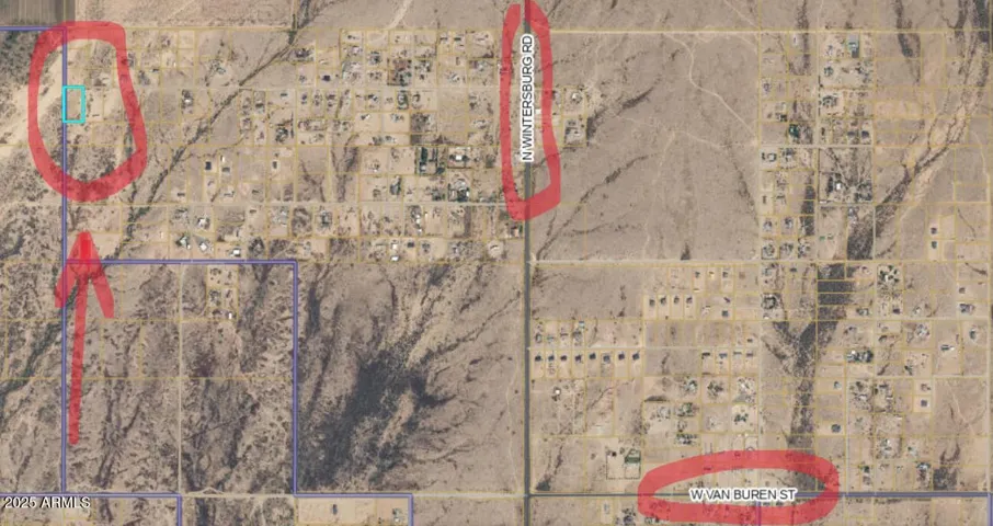


